filmov
tv
California Earthquake Update; M5.2 Earthquake Strikes South of Bakersfield

Показать описание
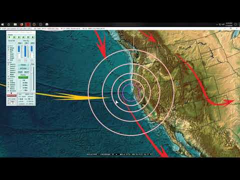
The strongest earthquake to strike southern California in 3 years just occurred, registering in as a magnitude 5.2. While only moderate in size, this earthquake surprisingly caused heavy shaking in some areas that would have been more typical of a larger magnitude 5.8 earthquake. So, why was this the case? The answer comes down to what the underlying ground is composed of, which this video will elaborate upon.
A special thanks to the EarthquakeSim YouTube channel for granting me permission to use clips of his footage!
Video Sources from the EarthquakeSim YouTube channel:
If you would like to support this channel, consider using one of the following links:
Google Earth imagery used in this video: ©Google & Data Providers
Various licenses used in sections of this video (not the entire video, this video as a whole does not completely fall under one of these licenses) and/or in this video's thumbnail image (and this list does not include every license used in this video and/or thumbnail image):
Sources/Citations:
[1] U.S. Geological Survey
0:00 California Earthquake
1:11 Aftershocks
2:08 Fault Type
2:58 Earthquake Intensity Comparison
 0:04:31
California Earthquake Update; M5.2 Earthquake Strikes South of Bakersfield
 0:14:08
Is this M5.2 SoCal Earthquake Swarm a Foreshock to a 'Big One'?
 0:03:18
New fault may have been revealed after M5.2 quake in Central Valley
 0:03:18
Magnitude 5.2 earthquake strikes near Bakersfield
 0:06:10
Large Earthquake M5.2 and Earthquake Swarm Petrolia, California, Mendocino Triple Junction
 0:23:07
6/05/2021 -- Large M5.2 Earthquake + Swarm strikes Southern California Salton Sea Volcano as warned
 1:31:33
9/09/2023 -- Large M6.9 earthquake in Morocco N. Africa -- M6.6 in Kermedecs + M5.2 in California
 0:01:56
Prelim. 5.2-magnitude earthquake, followed by 20+ aftershocks hit Southern California
 0:26:52
2/13/2017 -- Earthquake watch for North California -- Tahoe region M5.0 potential activity
 0:03:18
California Struck By 2 Moderate Earthquakes Within Hours Of Each Other
 0:00:22
Southern California hit with 5.3 magnitude earthquake
 0:00:31
Two earthquakes shake Northern California in same night
 0:28:51
10/10/2017 -- West Coast USA / Oregon struck by M5.2 earthquake -- Hidden EQ? Undersea Eruption?
 0:24:17
12/01/2020 -- Noteworthy Earthquake strikes West Coast -- M5.2 @ California / Nevada border
 0:02:23
5.3 Earthquake Near Bakersfield California.. Tuesday Night 8/6/2024
 1:10:05
1/12/2023 -- BE ALERT -- Earthquake unrest spreading now -- West Coast California / Oregon M5.0
 0:10:14
Late Night Gulf Of California Earthquakes M5.2
 0:00:59
Watching A M5.2 Earthquake Seismic Waves Arrive Live Via Raspberry Shake Seismograph
 0:00:29
Two earthquakes rattle Northern and Southern California
 1:00:01
1/14/2019 -- Earthquake Update -- M5.0 to M5.5 spread across Pacific -- M4.1 California coast
 0:29:23
9/13/2017 -- West Coast Earthquake -- M5.7 (M6.0) West of Los Angeles / California Coast
 0:09:19
This Week in Volcano News; Volcanic Tsunami Strikes, Taal Erupts
 0:00:35
Magnitude-5.8 Earthquake Hits Central California
 0:00:28
5.0 earthquake in Little Lake, Ca
Комментарии