filmov
tv
Tools for Stream and Catchment Delineation with QGIS

Показать описание
While proprietary GIS software offers a limited toolset for deriving streams and catchments from digital elevation models, QGIS has many tools for your workflows. Many tools come from Processing Provider plugins. This video explains what processing provider plugins are and gives an overview of the choices of tools for each step in the stream and catchment delineation workflow. Tools from QGIS core, SAGA, GRASS, WhiteboxTools and PCRaster will be discussed.
0:00 Introduction
0:42 Processing Provider Plugins
3:27 PCRaster
5:20 Generic workflow
6:03 Download DEMs
6:57 Mosaic DEM tiles
7:41 Reproject DEM
9:30 Subset DEM
10:02 Interpolate voids
10:17 Fill sinks
11:42 Flow direction
14:16 Burn-in the stream network
14:45 Delineate streams (Strahler and Flow Accumulation)
16:48 Define outlet
17:53 Automation and visualisation
#QGIS #QGISHydro #hydrology #gis
 0:19:24
Tools for Stream and Catchment Delineation with QGIS
 0:23:24
Stream and Catchment Delineation in QGIS 3 using GRASS tools
 0:33:40
Stream and Catchment Delineation in QGIS using SAGA Tools
 0:36:43
Complete Updated Workflow Stream and Catchment Delineation in QGIS
 0:17:50
Stream & Catchment Delineation with WhiteboxTools in QGIS
 0:12:25
Challenges with Stream and Catchment Delineation in QGIS?
 0:14:17
Automate Stream and Catchment Delineation in QGIS with the Graphical Modeler
 0:09:33
Delineate watershed area in QGIS || Delineate catchment area in QGIS
 0:08:04
How to Delineated Catchment and Morphometric Calculator Plugin
 0:21:13
Stream and catchment delineation with GIS (theory)
 0:00:57
New QGIS Processing Script for Automatic Stream & Catchment Delineation
 0:14:25
Deriving River Network and Catchments and Watershed Delineation from a DEM using QGIS
 1:21:10
Catchment and stream network delineation with QGIS
 1:11:52
QGISHydro Webinar 4: Stream & Catchment Delineation
 0:25:54
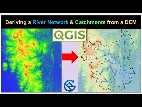
Deriving River Network & Catchments from a DEM using QGIS
 0:14:12
Derive all subcatchments from a DEM using PCRaster in QGIS
 0:08:51
QGIS 101: Map the Catchment - Mapping catchments & streams from DEM - Part 2 of 3
 0:12:19
Watershed Delineation Using DEM Data (Full) - ArcGIS
![[Whitebox #1]Delineate Catchment|Watershed|](https://i.ytimg.com/vi/zdM1BAdOFX8/hqdefault.jpg) 0:12:56
0:12:56
[Whitebox #1]Delineate Catchment|Watershed| Create Isobasin and Subbasin|From raster to vector
 0:15:59
5️⃣➖1️⃣Hydrology |Arc Hydro Tools Catchment Delineation and Calculating Morphological Data Part 1...
 0:05:57
Point Cloud to Bluespot, Stream and Drainage Basin (Catchment Area)
 0:09:04
Stream Order From DEM Using SAGA GIS
 0:10:03
Catchment and watershed extraction
 0:33:48
Deriving Rivers and Watersheds using ArcGIS Pro
Комментарии