filmov
tv
How To Decode a METAR Report- [Airline Pilot Tips and Practical Examples]

Показать описание
How to decode a metar report? This is a very common question that I get asked.
So, I decide to make a video where I help you to decode this meteorological report.
The Acronym METAR stands for Meteorological Aerodrome Report, this met report is used to get information regarding the actual weather at the selected Airport.
The METAR is issued at intervals of 30 or 60 minutes depending on the airport traffic.
It is important to understand that the structure of the METAR doesn't change, so, once you understand how to read one of this met report you will be able to read them all.
However, what changes, depending on the weather, are the codes within the METAR.
If you find a code that you don't know you can leave a comment below and I will help you out.
Depending on where you are there might be some differences within the met report.
For example, in Europe, the visibility is expressed in meter while in the USA is expressed in Statute Miles.
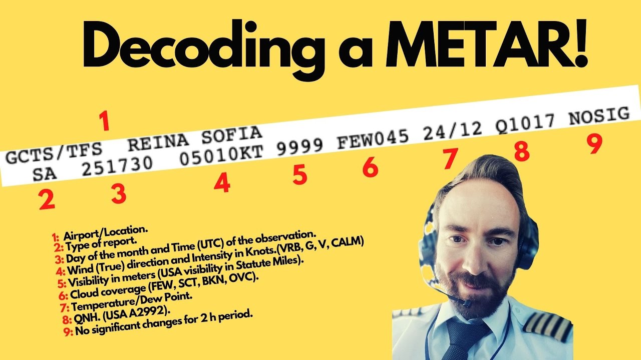
How do we read a Metar? I divided the metar into 9 sections:
1: Airport Codes/ Location,
2: Type of report,
3: Day of the month and Time (UTC) of the observation,
4: Wind (True) direction and Intensity in Knots. (VRB, G, V, CALM)
5: Visibility in meters (USA visibility in Statute Miles).
6: Cloud coverage (FEW, SCT, BKN, OVC).
7: Temperature/Dew Point.
8: QNH. (USA A2992).
9: No significant changes for 2 h period.
By the end of this video, you will be able to read a Metar and I will give some useful tips I learned after reading metar reports for the last 15 years.
Click on the below video if you want to know more about Temperature and dew point:
If you want to more about QNH watch the following video:
If want to know what CAVOK means watch the youtube video below:
If you feel like donating to the PILOTCLIMB channel you can send a PayPal or a crypto transaction to the addresses below:
Bitcoin address: 3DMaWztGYufX9WH33hSVNouwVpMEBA6m1t
Etherium address: 0x486fcA0234e2950D2068d1171379F5Efb36B911A
#PILOTCLIMB
==============================================================
Disclaimer:
THIS VIDEO IS FOR ENTERTAINMENT PURPOSES ONLY.
NOT FOR REAL-LIFE OPERATIONS.
PLEASE REFER TO THE OFFICIAL MANUAL AND DOCUMENTATION.
==============================================================
Комментарии
 0:06:32
 0:13:04
 0:07:33
 0:31:05
 0:11:57
 0:03:44
 0:10:27
 0:11:51
 0:10:34
 0:19:58
 0:32:31
 0:08:27
 0:11:54
 0:08:48
 0:14:37
 0:10:19
 0:00:49
 0:07:38
 0:03:53
 0:11:29
 0:21:54
 0:07:06
 0:13:25
 0:13:13