filmov
tv
All maps are a lie?! #maps #shortsindia #mythbusters

Показать описание
We have been Fooled 😱
Did you know this?
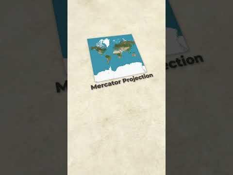
- In 1569, Mercator published his epic world map. This map, with its Mercator Projection, was designed to help sailors navigate around the globe. They could use latitude and longitude lines to plot a straight route.
- Mercator’s world maps flattened the spherical planet to make it easier to display. Displays of landmasses are not necessarily proportional to their actual size, especially toward the poles.
- The projection preserves the shape of all the countries and continents without distorting them but it distorts the land areas of the countries.
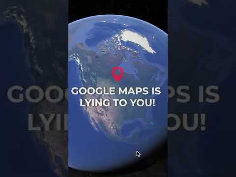
- But the Mercator map is still so widely used that even Google Maps uses it to give accurate directions.
- He also coined the term “Atlas” (named after the Greek mythological figure who held the world on his shoulders) to describe a collection of maps. Mercator continued his cartography work for the rest of his life, publishing parts of his atlas until his death in 1594.
- In 2017, Schools in the Boston district in the U.S. decided to switch from the Mercator’s Projection with the “Gall-Peters Projection”, which depicts continents and nations by their actual size, as proportional to one another.
- A popular one is the “Winkel Tripel Projection”, invented by Oswald Winkel in 1921 and named for his “Tripel” (German for “triple”) goals of minimising distortion of area, direction, and distance. It does the job pretty well, and the National Geographic Society adopted it as the standard map in 1998.
…
Share karo iss video ko sabke saath aur next kis topic par aapko videos chahiye, suggestions de do yaar, comments mein!
…
Sources :
- Vox: Gerardus Mercator revolutionized mapmaking. He was almost executed for it : 5th March 2015.
- Statista: The 30 largest countries in the world by total area : 2nd May, 2023.
- National Geographic: Gerardus Mercator
- Britannica: Atlas
- Science Direct: Mercator Projection
…..
#maps #worldmap #atlas #indianmap #googlemap #mercatorprojection #ias #upsc #civilservices #iasaspirants #aspirants #geography #geopolitics #kkcreate #map #3d #animation
Did you know this?
- In 1569, Mercator published his epic world map. This map, with its Mercator Projection, was designed to help sailors navigate around the globe. They could use latitude and longitude lines to plot a straight route.
- Mercator’s world maps flattened the spherical planet to make it easier to display. Displays of landmasses are not necessarily proportional to their actual size, especially toward the poles.
- The projection preserves the shape of all the countries and continents without distorting them but it distorts the land areas of the countries.
- But the Mercator map is still so widely used that even Google Maps uses it to give accurate directions.
- He also coined the term “Atlas” (named after the Greek mythological figure who held the world on his shoulders) to describe a collection of maps. Mercator continued his cartography work for the rest of his life, publishing parts of his atlas until his death in 1594.
- In 2017, Schools in the Boston district in the U.S. decided to switch from the Mercator’s Projection with the “Gall-Peters Projection”, which depicts continents and nations by their actual size, as proportional to one another.
- A popular one is the “Winkel Tripel Projection”, invented by Oswald Winkel in 1921 and named for his “Tripel” (German for “triple”) goals of minimising distortion of area, direction, and distance. It does the job pretty well, and the National Geographic Society adopted it as the standard map in 1998.
…
Share karo iss video ko sabke saath aur next kis topic par aapko videos chahiye, suggestions de do yaar, comments mein!
…
Sources :
- Vox: Gerardus Mercator revolutionized mapmaking. He was almost executed for it : 5th March 2015.
- Statista: The 30 largest countries in the world by total area : 2nd May, 2023.
- National Geographic: Gerardus Mercator
- Britannica: Atlas
- Science Direct: Mercator Projection
…..
#maps #worldmap #atlas #indianmap #googlemap #mercatorprojection #ias #upsc #civilservices #iasaspirants #aspirants #geography #geopolitics #kkcreate #map #3d #animation

All Maps are Lying to You 😱 The Real Size of Counties 🗺️
All Maps Lie! The Mercator Projection, The Most Commonly Looked at Map In The World, isn't So R...

Why Maps Lie 😳

Why all world maps are wrong

Europe's biggest Lie???🇪🇺😳

All maps are a lie?! #maps #shortsindia #mythbusters

How Maps LIE To You

How Maps LIE To You

Maps the greatest lie ever told ?

Why every world map is wrong - Kayla Wolf
I never knew that every map lied to us..😦 #shorts

Popular Map Of The World Is A Lie
World Map is Wrong #61

How the World Map Looks Wildly Different Than You Think

THE WORLD MAP WE ALL KNOW IS A COMPLETE LIE!! #Shorts

World Map is Wrong

How Maps Are Lying to Us. Four examples

World Maps Are A LIE!?

ALL MAPS LIE: You can't make a globe flat, so....

The Mercator Map Is A Lie

How your Maps are Lying to You

The biggest mistakes in mapmaking history - Kayla Wolf

Name All the Countries That Lie on the Equator

All Maps Lie! The Mercator Projection, The Most Commonly Looked at Map In The World LIES #shorts
Комментарии