filmov
tv
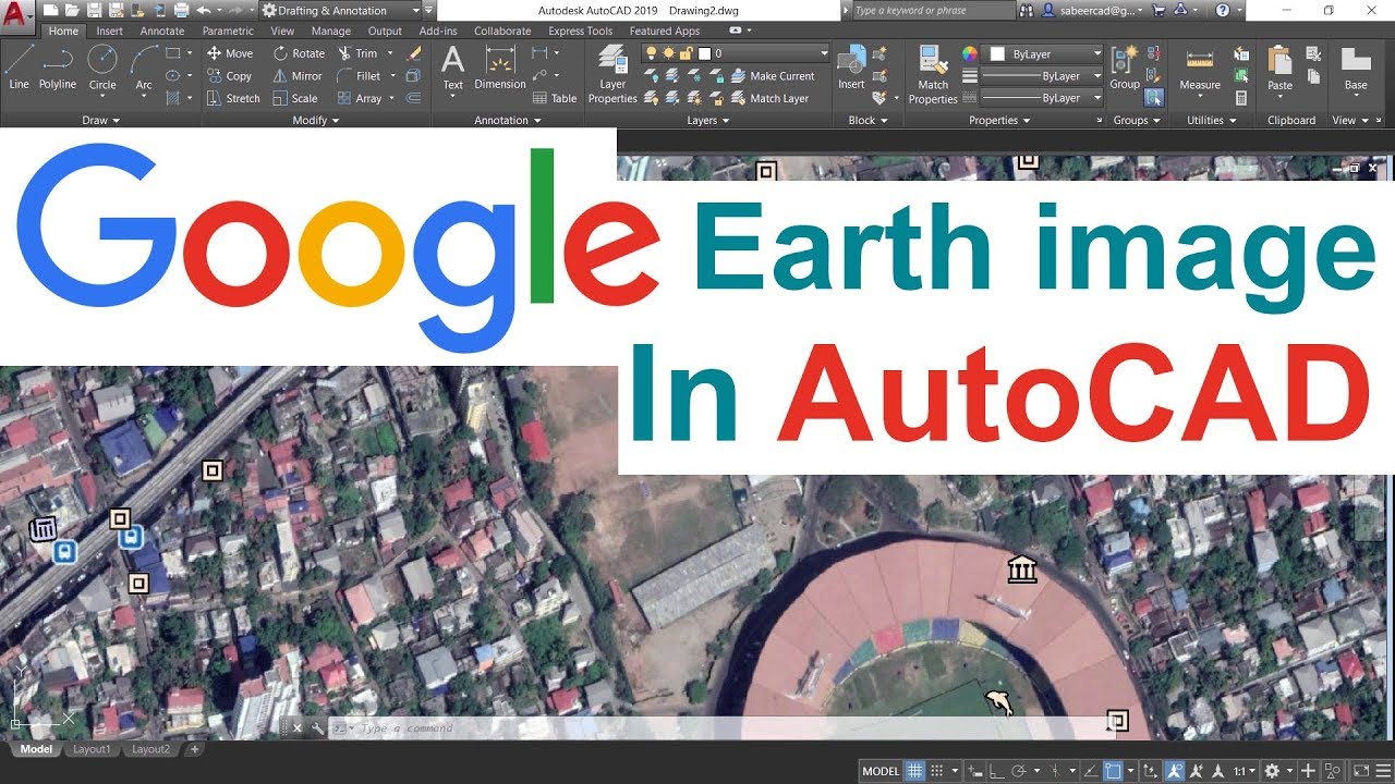
INSERTING GOOGLE EARTH IMAGE TO AUTOCAD | MAKE SITE PLAN IN AUTOCAD USING GOOGLE EARTH
Показать описание
INSERTING GOOGLE EARTH IMAGE TO AUTOCAD - This Tutorial video teaches the procedure to Insert a Google Earth image to AutoCAD software for various applications . You will also learn certain commands such as Attach , Align , Dist , Area etc.
#SabeerCAD #IntroductionToAutoCAD3D #AutoCADCivilModeling
THE STORY OF EVOLUTION - New features of AutoCAD 2021
Please LIKE this video if you liked it and SUBSCRIBE to my channel
Learn AutoCAD From Basics !
Here is the Best method to create 2D drawings from a 3D Model , there by you can save a lot of time and effort !
This is an Introductory video of a course in 3D Visualization using AutoCAD 3D , 3DSMAX and Adobe Photoshop .
Please Click Here and ENROLL !
Please Visit and Subscribe
 0:12:18
INSERTING GOOGLE EARTH IMAGE TO AUTOCAD | MAKE SITE PLAN IN AUTOCAD USING GOOGLE EARTH
 0:04:09
Image overlay in Google Earth Pro
 0:10:39
Adding a Google Earth Image to AutoCAD (and Georeferencing)
 0:03:59
Insert (Add) Photo to Google Earth Pro
 0:10:55
INSERTING GOOGLE EARTH IMAGE TO AUTOCAD | how to import google earth to AutoCAD?
 0:01:24
Adding a Photo in Google Earth
 0:05:42
Get High Quality Images from Google Earth Tutorial
 0:08:53
How to Download and Georeferencing Google Earth Image in ArcGIS
 0:08:59
Custom InfoWindow Google Map Flutter || Flutter Google Maps
 0:03:40
How to Insert Images on Placemark in Google Earth Pro
 0:08:14
Trick to download Google earth image and georeference it
 0:04:41
Google Earth Basics 16: Image Overlay Basics
 0:10:01
How to download Google Earth Image and Georeference it in ArcGIS software |Georeference ArcMap
 0:09:50
Inserting Google Earth Image to AutoCAD | Google Earth to AutoCAD
 0:11:33
Using Google Earth Images in QGIS
 0:06:43
Overlaying Images Over Google Maps & Satellite Images Using Google Earth: Ep. 150
 0:01:26
How to Add a Picture to a Placemark on Google Earth : Google & More Web Applications
 0:08:11
High Resolution Google Earth Image to AutoCAD & Georeferencing!!
 0:04:28
How to add a legend in Google Earth. How to create and edit an image overlay on Google Earth Pro
 0:02:59
Uploading geotagged photos to Google Earth
 0:07:23
AutoCAD Tutorial; Insert, georeference google earth image
 0:03:43
How to add the latest Google Earth images to ArcGIS directly
 0:00:35
Placing Google Earth image in ArchiCAD
 0:09:20
How to place ANYTHING in Google Earth 🌎
Комментарии