filmov
tv
Earthdata Webinar: NASA Space Geodesy Data for Precise Orbit Determination of Altimeter Satellites

Показать описание
Over the last 25 years, ocean radar altimeter satellites have revolutionized our understanding of the world’s oceans. Today six altimeter satellites from different national and international space agencies synoptically measure the ocean surface topography in order to determine how the ocean surface changes with time.
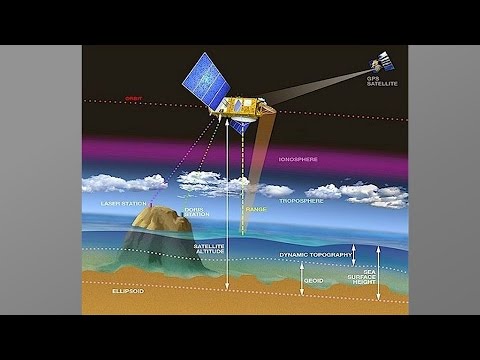
The heart of the altimeter measurement is the precise determination of the orbit reference which is used as the basis from which the changes in the ocean surface are determined. We now routinely determine the orbits of the joint NASA/CNES/NOAA/EUMETSAT missions Jason-2 and Jason-3 with a radial RMS precision of 1 cm.
During this webinar we will describe how we can compute these orbits with such accuracy, and will further outline how these computations rely directly and indirectly on a suite of international Space Geodesy data as well as data from different NASA satellites.
 1:09:15
Earthdata Webinar: NASA Space Geodesy Data for Precise Orbit Determination of Altimeter Satellites
 0:58:03
NASA Earthdata Webinar Series: Discover NASA's Archive for Space Geodesy Data: CDDIS
 1:09:06
Earthdata Webinar: Discover Earth Science Data with NASA Earthdata Search
 1:02:49
NASA Earthdata Webinar: Accessing Real-Time GNSS Data and Derived Products at the NASA CDDIS
 0:01:46
NASA | Space Geodesy Profile: Chopo Ma
 0:55:16
COMET Webinar: Dr Vicki Smith '2022: A Space Geodesy'
 1:08:16
NASA Earthdata Webinar: Discover NASA Near Real-Time Earth Science Data using LANCE
 1:05:28
NASA Earthdata Webinar: Discover NASA’s Updated Gridded Population of the World Data
 1:11:45
Earthdata Webinar: SeaDAS: Enabling the Study of our Planet from Space
 1:17:09
NASA CDDIS GNSS Products for Disaster Monitoring, Crustal Deformation, Extreme Weather, and More
 1:07:01
Earthdata Webinar Series: Simplified NASA Earth Science Data Access through OPeNDAP
 0:02:00
NASA | Space Geodesy Profiles: Jan McGarry
 1:03:56
Earthdata Webinar: Explore the Entire Earth, Every Day, with Satellite Imagery from NASA Worldview
 1:12:58
Increasing NASA Earth Science Data Accessibility with GIS
 1:03:29
NASA Earthdata Webinar Series: Real-Life Uses of Radar Data for Real-Life Scientists
 0:58:30
Discover NASA’s Near Real-Time Data using LANCE
 1:12:43
Space Geodesy and InSAR (ESP-SG) Lecture 1
 0:02:08
NASA's Space Geodesy Project - They Know Where They're At! | GSFC Satellite GPS HD Video
 1:14:37
Discover NASA Ocean Color Data and Services at OB.DAAC
 1:06:54
Earthdata Webinar: NASA ABoVE Data Management Best Practices
 0:03:41
Rising Seas More Accurately Measured From Space | Video
 0:01:48
FROM ERATOSTHENES TO SPACE GEODESY | Science & Space Video
 1:09:31
Web Unification: Optimizing Your Access to NASA Earth Science Data
 1:25:29
Science & Careers at NASA Webinar 12_12_16
Комментарии