filmov
tv
NASA Earthdata Webinar Series: Discover NASA's Archive for Space Geodesy Data: CDDIS

Показать описание
In this Webinar, we provide an introduction to the NASA Crustal Dynamics Data Information System (CDDIS), with background on space geodesy techniques and information about the types of scientific research and applications, enabled by the archive.
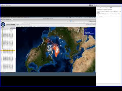
The Crustal Dynamics Data Information System (CDDIS) supports the space geodesy and geodynamics community through NASA's Space Geodesy Project as well as NASA's Earth Science Division within the Science Mission Directorate. The CDDIS was established in 1982 as a dedicated data bank to archive and distribute space geodesy related data sets. Today, the CDDIS archives and distributes mainly Global Navigation Satellite Systems (GNSS, currently Global Positioning System GPS and GLObal NAvigation Satellite System GLONASS), laser ranging (both to artificial satellites, SLR, and lunar, LLR), Very Long Baseline Interferometry (VLBI), and Doppler Orbitography and Radio-positioning Integrated by Satellite (DORIS) data for an ever increasing user community of geophysists.
The Crustal Dynamics Data Information System (CDDIS) supports the space geodesy and geodynamics community through NASA's Space Geodesy Project as well as NASA's Earth Science Division within the Science Mission Directorate. The CDDIS was established in 1982 as a dedicated data bank to archive and distribute space geodesy related data sets. Today, the CDDIS archives and distributes mainly Global Navigation Satellite Systems (GNSS, currently Global Positioning System GPS and GLObal NAvigation Satellite System GLONASS), laser ranging (both to artificial satellites, SLR, and lunar, LLR), Very Long Baseline Interferometry (VLBI), and Doppler Orbitography and Radio-positioning Integrated by Satellite (DORIS) data for an ever increasing user community of geophysists.
 0:59:40
 0:58:03
 0:54:21
 1:12:45
 1:12:02
 1:06:31
 1:09:06
 1:09:32
 2:18:26
 0:47:26
 1:05:28
 1:10:01
 0:50:56
 1:05:00
 1:08:16
 0:51:48
 0:53:15
 1:07:01
 0:49:39
 0:52:32
 0:44:32
 1:03:56
 0:11:11
 1:01:10