filmov
tv
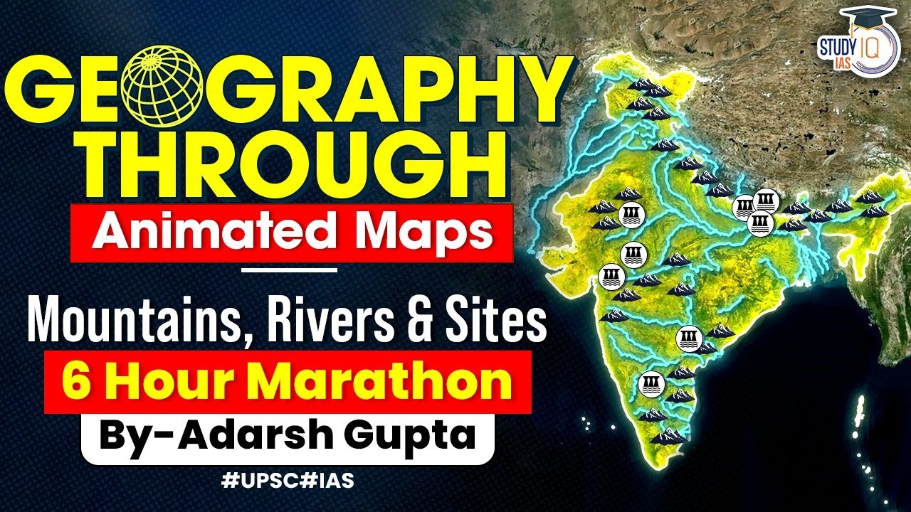
Understand Indian Geography through 2D Animation | Mountains, Rivers, Dams, National Parks | UPSC GS
Показать описание
Admissions Closing on 12th December 2023 | Daily Live Classes at 6:00 PM
In this video, embark on an engaging journey to understand Indian Geography using vibrant 2D animation. Dive deep into the intricacies of India's geographical features, including mountains, rivers, dams, and national parks. This visually immersive experience is tailored for UPSC GS preparation, providing a comprehensive overview of key geographical elements. Whether you're a UPSC aspirant or simply curious about India's landscape, this video offers an educational and visually enriching exploration.
UPSC IAS Live GS Foundation P2I Hindi Batch 5
बैच 14 दिसंबर 2023 से शुरू हो रहा है | बैच का समय शाम 6:00 PM
UPSC IAS Live GS Foundation P2I English Batch 4
Batch Started on 24th November 2023 | Daily Live Classes at 8:00 AM
UPSC IAS Live SIP+ 2024 Evening Batch 2
Batch Starting on 18th December'2023 | Class Timing - 5:00 PM
UPSC IAS Prelims to Interview ( P2I) 2024 Live Advanced Batch 6
Batch Started on 16th November 2023 | Daily Live Classes at 6:30 PM
(PSIR, Sociology, History, Geography, Pub Ad, Anthropology, Mathematics, Hindi Literature)
Set of 18 - General Studies books
UPSC IAS (Mains) PSIR Optional Live 2024 (Comprehensive) December Batch
Batch Starting on 13th December, 2023 | Class Timing -1:00 PM
UPSC IAS (Mains) Sociology Optional Live 2024 (Comprehensive) November Batch
Admissions Closing on 12th December, 2023 | Class Timing -1:00 PM
Uttar Pradesh PSC (Pre + Mains) Live Foundation Sampoorna Batch
Batch Starting on 18th December 2023 | Daily Live Classes at 6:00 PM
Bihar PSC (Pre + Mains) Live Foundation Sampoorna Batch
Batch Starting on 18th December 2023 | Daily Live Classes at 6:00 PM
Vipan Sir Courses - Courses to help you gain an edge with MCQs preparation
Buy our Best Selling UPSC CSE Books
From Online Stores
StudyIQ App/Store
Amazon
Flipkart
📌 Connect with [Our Social Media Platform] :
▀▀▀▀▀▀▀▀▀▀▀▀▀▀▀▀▀▀▀▀▀▀▀▀▀▀▀▀▀▀
 6:14:45
Understand Indian Geography through 2D Animation | Mountains, Rivers, Dams, National Parks | UPSC GS
 0:08:06
Indian Geography: Learn Coastal line of India | Smart Revision through Animation | OnlyIAS
 0:07:37
Mystery of Indian Monsoon | Confusing Topic in Geography | Revision through Animation | UPSC 2024
 0:20:13
Soils of India Explained through 3D Animation | Indian Geography | UPSC GS1
 0:11:46
Indian Geography: Peninsular Rivers of India | Smart Revision through Animation | OnlyIAS
 1:16:40
All Rivers of India through Animation | GS Geography for UPSC CSE Prelims & Mains
 0:00:57
Can you solve this 150 years old puzzle? #shorts
 0:12:41
Role of India's geography in shaping it's history | Linkage between history and geography ...
 0:06:20
How the World Map Looks Wildly Different Than You Think
 0:00:56
Epic earthquake building test
 0:09:52
Coastlines of India Explained Through Animation | UPSC Geography | StudyIQ IAS
 0:30:17
Complete Geography of North East India | North Eastern States | UPSC | StudyIQ IAS
 0:14:17
All Plateaus of India Explained Through Animation | Physiography of India | UPSC Geography
 0:05:36
Indian Geography Animated Course for SSC | Chapter 1 - Bharat ki sthiti aur vistar | UPSC GS .SSC !
 0:00:59
Indian Rivers & their tributaries | Part 1| UDAAN IAS|#india #geography #upsc #uppsc #ssc #ias #...
 0:03:13
Learn Indian Geography through 3D map.
 0:16:16
Indian States, Union Territories & their Capitals | 28 States & 8 UTs of India | UPSC Pre &...
 0:00:27
How to Answer Any Question on a Test
 0:01:00
😲What if you swallow a snake (ALIVE)? - By Kishor Singh #shorts
 0:00:59
Learn Indian Geography through 3D map #indiangeography #tlm #india #education #school #schoolproject
 0:00:56
ALERT! The 'MEAT SCAM' you can't even think of!😨 - By Kishor Singh #shorts
 0:00:53
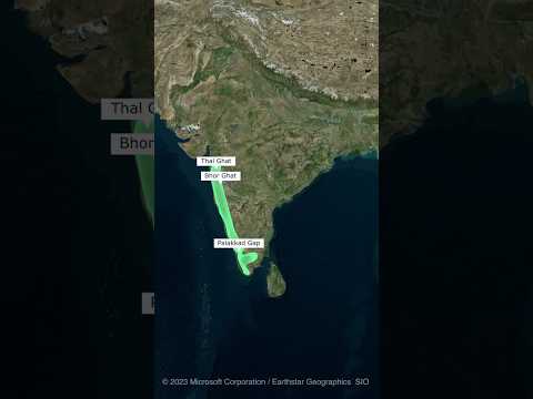
Western Ghats of India #india #geography
 0:00:16
Testing Stable Diffusion inpainting on video footage #shorts
 0:00:51
AP Scores are out today
Комментарии