filmov
tv
Satellite Images Reveal Stark Changes From Severe California Drought

Показать описание
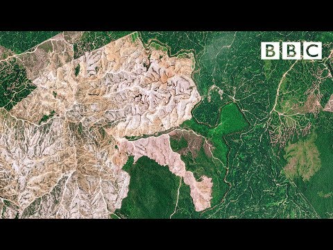
Two satellite images, taken about one year apart of the Angeles National Forest in southern California illustrate the drought that is gripping the state.
The two images were captured by the European Space Agency's Copernicus Sentinel-2 satellite.
One was taken in June 2020 and one in June 2021.
While last year's image shows the forest a lush green, the 2021 image shows it as brown. And reservoirs shown in the current image appear to be almost dry.
Bloomberg Quicktake brings you live global news and original shows spanning business, technology, politics and culture. Make sense of the stories changing your business and your world.
Connect with us on…
 0:00:26
Satellite Images Reveal Stark Changes From Severe California Drought
 0:01:52
Satellite shows extent of terrible destruction to the planet - BBC
 0:24:59
27 Satellite Images That Cannot Be Explained By Scientists
 0:19:58
15 Incredible Satellite Images
 0:01:11
UK Heatwave: Stark Images Show Impact of Drought on Britain
 0:03:48
World's First City Discovered by U.S. Spy Satellite
 0:22:19
Bill Nye BREAKS SILENCE On The TERRIFYING New Image By James Webb Telescope That Changes Everything!
 0:03:06
Stephen Hawking's Stark Warning for Humans to Leave Earth
 0:31:48
James Webb Telescope Reveals There Is LIFE On Proxima B!
 0:01:21
Nexus War Launch Trailer for Fortnite Chapter 2 - Season 4
 3:11:14
James Webb Telescope Reveals the MOST TERRIFYINGLY CLEAR Image of Proxima B
 0:02:48
Death Of The Avengers - Tony Stark's Vision Scene - Avengers: Age of Ultron (2015) Movie CLIP H...
 0:29:20
Bill Nye BREAKS SILENCE On The TERRIFYING New Image By James Webb Telescope That Changes Everything!
 1:11:42
J. Webb Telescope Just Revealed Terrifying New Images That We’ve Never Seen Before!
 0:28:37
Alien Photos From History That Prove They're Real
 3:05:06
James Webb Telescope Just Announced The Clearest Image Of Proxima B Seen In History!
 0:04:35
Tony Stark Figures Out Time Travel Scene | Avengers Endgame (2019) IMAX Movie Clip HD 4K
 0:02:08
Tony stark 'when did you became master in thermo nuclear astro physics' The Avengers (201...
 0:03:05
Emilia Clarke LOSES IT At Phoebe Waller-Bridge’s Ridiculous Story | Graham Norton's Good Story ...
 0:03:19
Ancient Aliens: HIDDEN ALIEN CODE IN DNA UNCOVERED (Season 13) | History
 0:02:36
The Evolution of Jason Voorhees (Animated)
 0:03:12
'On Your Left' Steve Rogers & Sam Wilson - Running Scene - Captain America: The Winter...
 0:00:52
Sonic The Hedgehog 2 - First look at Shadow The Hedgehog | 2022
 0:30:14
Elon Musk & Brian Cox Reveals Betelgeuse Star Explosion Will Make DIRECT Impact in 2 Weeks!
Комментарии