filmov
tv
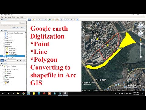
Digitizing in ArcMap Using Portable Server I Geo database Design and Project Area Mapping in ArcGIS

Показать описание
This tutorial will help you to design a File Geo-database for your project data mapping.
Here, you will learn everything about project area mapping. In first chapter, how to create File Geo-database, Feature Datasets, Feature Class & Domain. And than we will do a real project mapping using ArcMap. Where we will creating point, line and polygon features for our project. Finally we have export our project area mapping.
If you have any queries, do comment. Thank you.
Chapters
-------------------
00:00 Information About Geo-database
01:04 Create File Geo-database (Domain, Feature Class)
10:43 Add Portable Base Map Server
13:41 Start Digitization
38:55 Map Layout and Export the Map
Download Portable Base map Server:
#ArcGIS #GIS #Geographic_Information_System #Geospatial_Lab #GeoL #Vector #Spatial_Data #Cartography #Bhasan_Char #Map_Layout
#File_Geodatabase, #Feature_Dataset,#Geo_database_Design, #Digitizing, #ESRI #Geography #Mapping,
 0:43:01
 0:14:33
 0:00:35
 0:08:44
 0:01:21
 0:03:37
 0:00:21
 0:01:29
 0:27:17
 0:16:53
 0:11:22
 0:21:33
 0:20:57
 0:13:20
 0:48:50
 0:04:11
 0:03:10
 0:31:36
 0:05:12
 0:37:11
 0:09:41
 0:05:51
 0:05:11
 0:33:02