filmov
tv
How to interpolate surfaces in ArcGIS Online

Показать описание
How to interpolate surfaces in ArcGIS Online web based GIS. Here, the example focuses on weather data, but you can use the same techniques to interpolate surfaces for any set of point data. As always, pay close attention to the distribution, number, and quality of your input dataset.
 0:03:47
How to interpolate surfaces in ArcGIS Online
 0:04:16
Interpolation: Kriging using ArcGIS
 0:01:30
Interpolate Values within Contour Surface
 0:05:31
Interpolation in 5 minutes
 0:51:52
Spatial interpolation techniques
 0:02:31
03 09 05 Visual Tips 5: Interpolate on Surface
 0:04:44
Create and Interpolate to an Offset Surface
 0:04:10
Interpolate Cross Section Data Using Triangulation
 1:04:45
UW-AOS Department Seminar - October 2, 2024 - Emily Mather
 0:03:51
0049. interpolate curve on surface in rhino
 0:10:59
How to interpolate from a set of (x,y,z) points in Excel and Google Sheets with INTERPXYZ()
 0:00:53
Interpolate Shape Tool | Functional Surface Toolset | 3D Analyst ArcToolbox
 0:01:23
Civil 3D Create Points Interpolate (Object)
 0:02:44
Interpolate Shape from Surface (MMC Bathymetry Tools Toolbox)
 0:03:50
How to interpolate point data with environment setting in ArcGIS
 0:02:34
Interpolate Cross Section with 3D Line Method
 0:12:20
Chapter 14: Interpolation
 0:05:18
Advanced Interpolation
 0:17:28
How to interpolate elevation values on Model Muse
 0:02:37
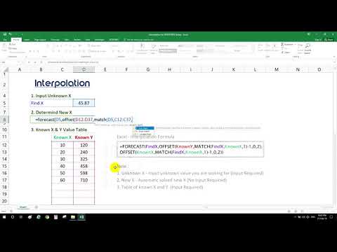
Quickly Interpolation by Excel
 0:01:22
GIS: How to interpolate a raster surface from linear vector input?
 0:01:33
ESurvey Interpolate Tutorial Introduction
 0:12:10
How to Plot CONTOURS on a SURVEY PLAN with REDUCED LEVEL(R.L.) Points/ Interpolation of CONTOURS
 0:01:51
Tips film: Helical Interpolation
Комментарии