filmov
tv
Satellite images show smoke from California fires spreading almost a thousand kilometers

Показать описание
California is experiencing major, sustained wildfires along with a heat wave that has produced what has been called a “heat dome”.
Smoke from these wildfires has created extremely unhealthy air quality throughout several regions.
The smoke has travelled across California all the way to Minnesota and Nebraska and air currents will carry the smoke across the entire U.S.
The fire forced thousands to flee and destroyed hundreds of houses and other structures.
Red flag warnings continue to be issued in California and in the states of Montana, Idaho, Utah, and Colorado, where other major wildfires are occurring.
Satellite images show smoke from wildfires has drifted 965km miles into the Pacific Ocean.
According to NASA, so far in 2020, California has seen 7,000 incidents that have affected more than 1.4 million acres of land, which is equivalent to four times the amount burned in 2019.
#CaliforniaFire
 0:00:30
Satellite images show wildfire smoke blowing across Hawaiian islands
 0:01:09
Satellite images show smoke rising from damaged Crimea bridge
 0:03:00
Satellite images show smoke of U.S. western wildfires from space | WION
 0:00:34
Satellite Images Show Smoke Rising From Southern California Wildfires
 0:00:57
Satellite Images Show Canadian Wildfire Smoke Moving Across U.S. | WSJ News
 0:01:24
Satellite images show smoke from California fires spreading almost a thousand kilometers
 0:01:18
WILDFIRES IN CANADA | Satellite images show smoke rising over Yellowknife, Kelowna
 0:01:01
Satellite Imagery Shows Large Smoke Clouds From New Mexico Wildfire
 0:00:24
Raw Video: NOAA Weather Satellite Image - Smoke From Grand Prairie Fire
 0:00:40
Smoke From Western Wildfires Blankets U.S.
 0:01:04
Maui Wildfires Appear on Satellite Imagery
 0:00:46
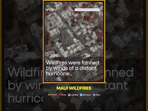
Satellite images show scale of devastation from Maui wildfires
 0:00:18
Satellite Animation Shows Smoke from California's Springs Fire
 0:00:56
Satellite imagery shows smoke billowing from Russian Naval HQ after Ukrainian strike
 0:00:24
Satellite footage shows smoke from Canada wildfires barreling towards US
 0:03:07
Satellite Imagery Shows Total Devastation Across Maui With Before-and-After Pictures
 0:03:08
Satellite Imagery Shows Smoke from the Proletarsky, Rostov Oil Depot Fire Extends 105 Kilometers
 0:00:35
Satellite Images Show Calf Canyon/Hermits Peak Fire in New Mexico
 0:00:18
Bay Area Orange Sky: Satellite Shows Smoke Blanketing California
 0:00:09
GOES-16 Geocolor Imagery of Smoke from Wildfires in British Columbia, Montana and Idaho
 0:02:11
Maps, satellite images show destruction across Australia – but they can be misleading
 0:01:02
Photos show smoke from Canadian wildfires lingering over Capitol, obscuring NYC skyscrapers
 0:00:34
Satellite pictures show huge Tonga volcano blast
 0:00:20
Satellite footage shows wildfire smoke from Canada spreading over Midwest
Комментарии