filmov
tv
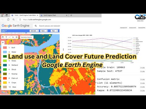
Predict Future Land Cover in Google Earth Engine

Показать описание
Do you have two land cover data in two different years and want to know what it will be in the future? You are in luck! I have just a simple script to predict land cover in the future.
In this video, I am using two landcover data in Palembang city in the years 2019 and 2022 derived from Sentinel-2 dataset. To predict, you need a land cover change map first formed from the transition of land cover data between years. Then I build a random forest model using the first, and last landcover, the change map, elevation, and year data. To predict future land cover, you need to apply the model to the new variables of images.
In this video, I am using two landcover data in Palembang city in the years 2019 and 2022 derived from Sentinel-2 dataset. To predict, you need a land cover change map first formed from the transition of land cover data between years. Then I build a random forest model using the first, and last landcover, the change map, elevation, and year data. To predict future land cover, you need to apply the model to the new variables of images.
 0:07:17
Predict Future Land Cover in Google Earth Engine
 0:14:39
Prediction of Land Use/Land Cover Change using QGIS and ArcGIS (2010-2020-2030)
 0:00:22
Prediction of Future Land Use with GIS CA Markov Machine Learning
 0:13:42
Prepare future Land Use Change Prediction Map using Google Earth Engine and ArcMap
 0:15:53
LULC Prediction Tutorial Part 1:Prepare future Land Use Change Prediction Map | Variable preparation
 0:10:15
Future Prediction of LULC Using Cellular Automata Model || ANN || CA-Marko Chain || QGIS || ArcMap
 0:15:41
LULC Prediction Tutorial Part 3: Prepare future Land Use Change Prediction Map
 0:18:46
Part 1: Land Cover Classification in Google Earth Engine for Simulated Future Land Cover Change
 1:19:37
Numerai & Predictoor: How AI Changed Crypto Prediction Markets - Trent McConaghy & Richard C...
 0:19:54
LULC Prediction Tutorial Part 1: Land Use/Land Cover Map
 0:14:04
FUTURE PREDICTION (2030, 2040 And 2050) With Help OF QGis
 0:09:49
LULC change detection & Prediction with MOLUSCE Tool in QGIS
 0:10:44
Land use Land Cover (LULC) Prediction Map (2025) Using Random Forest Classifier ||Google Earth Engin
 0:13:52
Part 3: Simulated Land Cover Change for Future using MOLUSCE plugin
 0:14:05
Land Use Land Cover or Urban Growth Prediction Using IDRISI SELVA and TERRASAT | Tech Geographer |
 0:14:36
Prediction of Land Use/Land Cover Change using QGIS and ArcGIS (2010-2020-2030)
 1:18:51
Prepare future Land Use Change Prediction Map using Google Earth Engine part:1
 0:11:34
Future Predicated Map With Help Of Qgis OF LULC Classification ‖ Using Molusce Tool
 0:03:32
How to validate land use land cover prediction in IDRISI Selva and Terrasa || Tech Geographer ||
 0:29:09
How to predict Land use land cover change by using CA Marcov chain model on Terrset software
 0:10:01
Land use/Land cover Change detection Analysis for an Area over a certain timeline like 1989 to 2020
 0:08:56
LULC Prediction Tutorial Part 2: Variables Preparation (Distance from Road, River, Slope etc.)
 0:11:28
Prediction of LULC changes for species distribution modeling using cellular automata and ANN
 1:13:10
🛑How to make LANDUSE AND LAND COVER CHANGE mapping using Google Earth Engine | LULC change detection...
Комментарии