filmov
tv
Calculate Flow Direction Using PCRaster in QGIS3

Показать описание
Use a DEM to carry out flow direction analysis in QGIS 3. PCRaster plugin is used. Go to the PCRaster site for guidance on installing it in QGIS. The following steps are followed:
1) Convert GeoTIFF to PCRaster Format. The raster has to be converted to the PCRaster map format in order to use the PCRaster tools because PCRaster is strict with data types.
2) Fill Sinks and Calculate Flow Direction. DEMs have artifacts such as depressions and these must be removed before a DEM can be used for hydrological analysis. The lddcreate tool of PCRaster fills the sinks and creates a flow direction map (also called local drain direction map). This will be used in the next videos to delineate streams and catchments (check out the videos on my page)
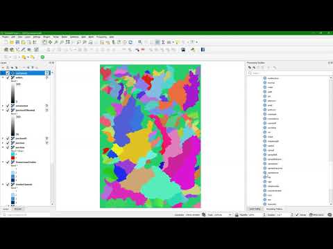
3) Styling the flow direction QGIS. Flow direction shows the direction of flow for each pixel. The
PCRaster lddcreate tool uses numbers on the numeric pad which are in a complicated order to style. First, we have to first reclassify the flow direction values using values (0 = North, 1 = North East, 2 = East, 3 = South East, 4 = South, 5 = South West, 6 = West, 7 = North West, 255 = Flat). We then use the reclassified layer to style and label the flow direction.
Chapters
0:00 Convert GeoTIFF to PCRaster Format
0:34 Fill Sinks and Calculate Flow Direction
1:31 Reclassify the flow direction
3:43 Style the reclassified layer to show the flow direction from North direction clockwise to Northwest
1) Convert GeoTIFF to PCRaster Format. The raster has to be converted to the PCRaster map format in order to use the PCRaster tools because PCRaster is strict with data types.
2) Fill Sinks and Calculate Flow Direction. DEMs have artifacts such as depressions and these must be removed before a DEM can be used for hydrological analysis. The lddcreate tool of PCRaster fills the sinks and creates a flow direction map (also called local drain direction map). This will be used in the next videos to delineate streams and catchments (check out the videos on my page)
3) Styling the flow direction QGIS. Flow direction shows the direction of flow for each pixel. The
PCRaster lddcreate tool uses numbers on the numeric pad which are in a complicated order to style. First, we have to first reclassify the flow direction values using values (0 = North, 1 = North East, 2 = East, 3 = South East, 4 = South, 5 = South West, 6 = West, 7 = North West, 255 = Flat). We then use the reclassified layer to style and label the flow direction.
Chapters
0:00 Convert GeoTIFF to PCRaster Format
0:34 Fill Sinks and Calculate Flow Direction
1:31 Reclassify the flow direction
3:43 Style the reclassified layer to show the flow direction from North direction clockwise to Northwest
 0:06:04
 0:03:04
 0:09:41
 0:20:56
 0:05:32
 0:00:40
 0:12:32
 0:07:05
 0:08:43
 0:03:05
 0:07:29
 0:14:12
 0:11:00
 0:25:49
 0:12:40
 0:14:20
 0:21:37
 0:11:20
 0:15:17
 0:06:54
 0:00:59
 0:03:02
 0:01:33
 0:06:15