filmov
tv
Converting Point Data to Kernel Density Layer and to Polygon Data

Показать описание
For Jedi Geographers!
This video tutorial demonstrates the multi-step process by which you can turn multiple years of point data (representing individual crimes) into a graduated point layer (using the collect events tool) and then into a kernel density 'hot spot' map (raster layer) and then convert the values from the raster layer's pixels (kernel density) into a table that can be joined to a polygon map (in this case a census block group layer) - so that you can get a count (or rate) of crimes in a neighborhood that would reduce the problem of crimes counting only in a single census tract (zip code, or other polygons based map) when crimes should perhaps be accounted to some degree in adjacent polygons, zip codes or census tracts as well. This also helps mitigate randomly slightly misplaced boundaries lines, or inaccurate geocoding that tends to create overcounts and/or undercounts crimes on one side of a polygonal boundary.
Data: Los Angeles Sheriff Department (2021)
Music:
Music by Complete Strangers, Song "Sweet Disarray"
Converting Point Data to Kernel Density Layer and to Polygon Data
 0:03:18
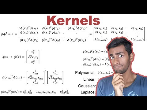
The Kernel Trick in Support Vector Machine (SVM)
 0:07:30
The Kernel Trick - THE MATH YOU SHOULD KNOW!
 0:14:59
Crime Geography: Kernel Density Smoothing & Zonal Statistics - point data to census tract data.
 0:09:45
FFCO Crime Part 2 Kernel Density
 0:11:41
ArcPro: Creating a Kernel Density (hotspot) Map and Converting to Point
 0:02:02
Calculating Kernel Density from point locations in ArcMap: Coyote exercise
 0:06:31
GIS Tutorial: Feature to Point Conversition for Kernel Density
 0:03:36
Determine Kernel Density in ArcGIS | ArcGIS
![[MXML-6-05] Support Vector](https://i.ytimg.com/vi/NiuJihA05Ds/hqdefault.jpg) 0:17:53
0:17:53
[MXML-6-05] Support Vector Machine (SVM) [5/10] - Nonlinear SVM: Kernel trick
 0:33:37
Wildlife Analysis in ArcGIS Pro: Using Kernel Densities to estimate Home Ranges and Core Areas
 0:09:46
What is Kernel Trick in Support Vector Machine | Kernel Trick in SVM Machine Learning Mahesh Huddar
 0:09:14
ArcPro: Zonal Statistics from Crime Kernel Density Estimation (Hotspot Map)
 0:50:01
Kernel Recipes 2016 - Kernel documentation: what we have and where it’s going - Jonathan Corbet
 0:11:16
The Kernel Trick in Support Vector Machine (SVM) || SVM Machine Learning Classifier
 1:02:22
688 S21 Lecture 23 - Kernel PCA
 0:10:16
26 6 Kernel PCA 1080p
 0:02:36
Kernel density processing extent
 0:06:36
13. Kernel Density Map to ArcGIS | ArcGIS for Beginner
 0:31:09
SVM 5 - the kernel trick
 0:06:11
Kernel density
 0:17:54
Hotspot / Kernel Density Analysis : Change Detection in Arcgis
 0:00:24
At least 1 fig we eat has a 💀 female wasp inside. Find out why with me🌱 #fig #howtowithjessie
 0:45:40
Does making the kernel harder make making the kernel harder?
Комментарии