filmov
tv
WAvES declination method

Показать описание
WAvES can be used to adjust for magnetic declination. WAvES is a mnemonic meaning West Add vs East Subtract and it will work anywhere whether you’re an area with a West of East declination.
As with everything concerning navigation it will require some practice so next time you’re out in the hills, have a try at adjusting y6our compass for the magnetic declination in your local area.
As with everything concerning navigation it will require some practice so next time you’re out in the hills, have a try at adjusting y6our compass for the magnetic declination in your local area.
 0:10:45
WAvES declination method
 0:05:13
Magnetic Declination Explained | Your Compass Needle Does NOT Point North!
 0:01:59
How to Set Declination on a Compass | Outside Watch
 0:00:57
Setting the declination of a Silva-Suunto compass-clinometer
 0:08:12
Declination when doing a resection
 0:29:05
Using A Compass with a Maps and Adjusting for Declination
 0:15:41
How to use Your Compass: Magnetic Declination
 0:04:04
Navigation - How to adjust over time for change in declination - Pt. 2
 0:00:15
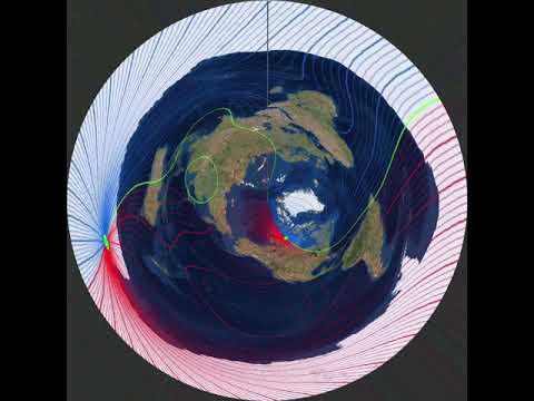
Magnetic Declination on Azimuthal Equidistant map 1590-2020
 0:15:50
DECLINATION, BEARINGS, and TRIANGULATION - Navigation (6 of 11)
 0:07:57
Declination Diagrams on a Topographic Map
 0:05:31
Setting Compass Declination and Orienting Your Map
 0:13:01
HOW TO CALCULATE COMPASS ERROR ONBOARD #navigation #officer #merchantnavy #lifeatsea
 0:10:50
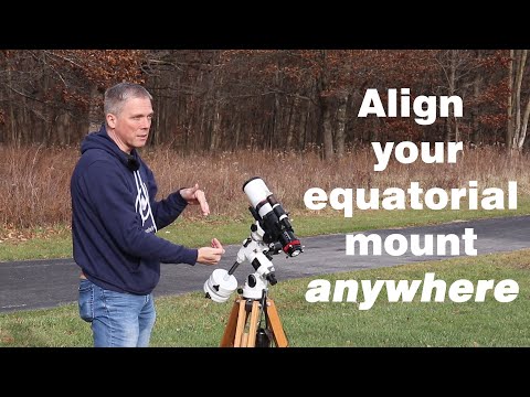
Align equatorial mount when unable to see pole star (north or south)
 0:18:31
THIS is how to use a compass: (very) simplified
 0:04:18
Slope angle with or without a clinometer
 0:06:50
Does Compass Declination Matter?
 0:03:35
How to Measure Distance With A Compass
 0:00:45
Moon Phase Animation
 0:06:14
Gyro Error by Amplitude (Basic)
 0:03:18
[ JEE MAINS ]DIP IN GEOMETRIC MERIDIAN AND ITS DECLINATION [ SCHOOL PHYSICS ]
 0:01:30
True south vs magnetic south
 0:03:20
Phases of moon explained using an orrery
 0:17:57
Magnetism
Комментарии