filmov
tv
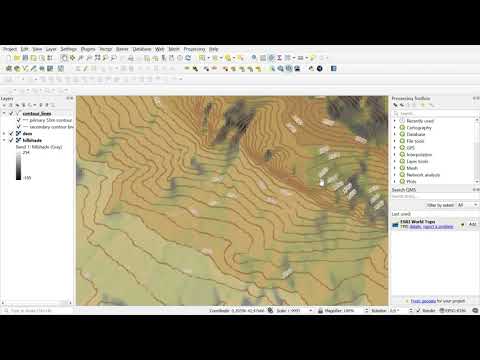
Elevation data in QGIS without DEM

Показать описание
This tutorial explains how to acquire the elevation data for any place on the Earth WITHOUT applying the Digital Elevation Model. The process is much more convenient in selecting the area and defining the density of single points, unlike Google Earth, where we have to draw a very long path.
Read more here:
Read more here:
 0:26:19
Elevation data in QGIS without DEM
 0:04:12
Free Download Digital Elevation Model Data & Visualization in QGIS || No Registration || No Log ...
 0:01:26
#8 QGIS Raster Define No Data Value
 0:11:05
Downloading SRTM DEM data using QGIS
 0:06:24
How to Download Digital Elevation Models (DEM) in QGIS [OPENTOPOGRAPHY]
 0:03:18
QGIS: DEM no data issue| Close gaps| Raster no data
 0:02:51
How to fill no data cells in QGIS
 0:30:59
Prepare Elevation Map with Contour Lines in QGIS | Latest Tutorial
 0:00:57
Elevation data from data.nextgis.com in QGIS
 0:15:57
How to Draw Contour in QGIS without visiting site | (English)
 0:14:54
Assign elevations from a DEM automatically in Qgis ( Drape points)
 0:04:32
QGIS Demo 22: Raster NoData
 0:02:43
GIS: SRTM elevation data download error QGIS
 0:05:32
Dealing with NoData in Discrete Rasters using QGIS
 0:01:32
Open elevation data from data.nextgis.com in QGIS
 0:05:15
Create DEM in QGIS using data from Google Earth Pro
 0:10:33
QGIS Raster Calculator for No Data Values and Thresholds (Version 3.x)
 0:01:27
Open a Digital Elevation Model (DEM) in QGIS
 0:00:26
#QGIS Quick Tip #2 - The Identify Feature Tool
 0:03:41
HOW TO REMOVE BLACK BACKGROUND (no data) FROM DEM FAST! - QGIS
 0:11:29
QGIS BASEMAPS: the ULTIMATE GUIDE
 0:04:19
Visualizing Survey and DEM data in QGIS
 0:06:25
Elevation Data for North America in QGIS
 0:08:26
QGIS Raster Calculator | Raster Calculator for Elevation Values Extraction | DEM
Комментарии