filmov
tv
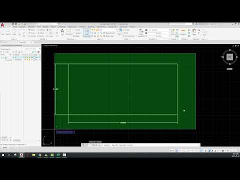
Show All Dimensions on any AutoCAD Drawing with help of AutoLisp with Just one Click |PDIM| Civil 3D

Показать описание
In This Short Video Tutorial, I will explain how to Show All Dimensions on any AutoCAD Drawing with help of AutoLisp with Just one Click |PDIM| Civil 3D.
#autocad #autolisp #civil3d #dimension #autodesk
AutoLisp Download Link:
Related Videos:-
1)How to Change Background Color Settings in Civil 3d
2)How To Import Points In Civil 3D Ch# 01
3)How to Create Surface with Contours and Basic Drawing settingsN Ch# 02
4)How To Draw Road Alignment In Civil 3D CH# 03
5)How To Draw and Prepare Survey As built Data in Civil 3D and Export Data to Excel
7)How To Draw Simple Road Profile By Using Lisp. CH# 06
8)How To Prepare Leveling Control Report Road alignment,as built,Export data to Excel. CH# 07
9) How To Import X,Y,Z Coordinates From Excel To Auto cad. CH# 08
10) HOW TO DRAW COORDINATES ON ROAD ALIGNMENT / CENTER LINE . CH# 09
11) 1)How to Change background Color Settings in Civil 3d
2)How To Import Points In Civil 3D Ch# 01
3)How to Create Surface with Contours and Basic Drawing settingsN Ch# 02
4)How To Draw Road Alignment In Civil 3D CH# 03
5)How To Draw and Prepare Survey As built Data in Civil 3D and Export Data to Excel
6) How To Calculate Volume In Civil 3D. CH# 05
7)How To Draw Simple Road Profile By Using Lisp. CH# 06
8)How To Prepare Leveling Control Report Road alignment,as built,Export data to Excel. CH# 07
9) How To Import X,Y,Z Coordinates From Excel To Auto cad. CH# 08
10) HOW TO DRAW COORDINATES ON ROAD ALIGNMENT / CENTER LINE . CH# 09
11) Create Surface Profile and Profile Views. CH# 10
12) How To Draw Road Widening In Civil 3D. CH#11
13) How To Do Link Excel Data To AutoCAD. CH# 12
14) How to Create Road Profile in AutoCAD Civil 3D Road Design Profile on Existing CH# 13
15) How to Create Surface Profile from File In AutoCAD Civil 3D. CH# 14
16) 5 Best Ways To Create Best Fit Alignment and Profile In Autocad Civil 3D. CH#15
18) How To Add and Edit New Profile Bands In AutoCAD Civil 3D. CH#17
20) How to Save and Import Profile Bands In AutoCAD Civil 3D. CH#19
21) How to Create Road Assembly in AutoCAD Civil 3D . CH#20
22) How to Create Corridor |Road| in AutoCAD Civil 3D. CH#21
23) How To Create Corridor Surface and Sample Lines. CH#22
24) How to Draw Road Cross Sections In AutoCAD Civil 3D. CH#23
25) How To Calculate Road Cross Section Volume In AutoCAD Civil 3D. |Earth Work, Table and Report| CH#24
26) How to Draw Existing Ground, Finish Ground and Cut Fill Surface Elevation In AutoCAD Civil 3D CH# 25
27) How To Calculate Cut and Fill Surface Volume With Spot Elevation In AutoCAD Civil 3D. CH#26
28) How to Create Manual Points By Using Slope|Distance in AutoCAD Civil 3D. CH#27
29) How To Calculate Super Elevation (S.E) |What is Super Elevation|. CH# 28
 0:00:40
 0:07:26
 0:02:47
 0:00:22
 0:04:11
 0:02:06
 0:06:24
 0:00:55
 0:05:24
 0:01:23
 0:23:53
 0:06:56
 0:05:35
 0:09:56
 0:06:02
 0:03:45
 0:05:38
 0:10:48
 0:00:26
 0:04:59
 0:05:01
 0:07:52
 0:13:52
 0:01:13