filmov
tv
NCyTE Member Meeting: Satellites, Positioning, GNSS vs GPS, and Potential Security Vulnerabilities

Показать описание
Presenter: Vincent DiNoto Jr.
Director of the National Geospatial Technology Center of Excellence (GeoTech Center)
Co-PI of the National Center of Autonomous Technology
Professor of Physics, Astronomy, and Geospatial Technology
Dean of College and Systemic Technology
Data pathways will be explored concerning geospatial technologies and the requirements between open-source data, information security, and geospatial ethics.
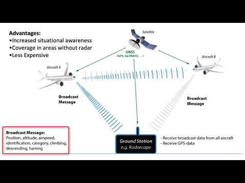
As technologies are developed for autonomous transportation, it is critically important that the positional location data is kept secure. Typically through the use of the Global Navigation Satellite System (GNSS), often referred to as Global Position System (GPS), as well as ground-based transponders.
Positional awareness through the use of location data, as well as open-source services such as Open Street Map (OSM) will be discussed.
Director of the National Geospatial Technology Center of Excellence (GeoTech Center)
Co-PI of the National Center of Autonomous Technology
Professor of Physics, Astronomy, and Geospatial Technology
Dean of College and Systemic Technology
Data pathways will be explored concerning geospatial technologies and the requirements between open-source data, information security, and geospatial ethics.
As technologies are developed for autonomous transportation, it is critically important that the positional location data is kept secure. Typically through the use of the Global Navigation Satellite System (GNSS), often referred to as Global Position System (GPS), as well as ground-based transponders.
Positional awareness through the use of location data, as well as open-source services such as Open Street Map (OSM) will be discussed.
 0:44:31
 0:33:00
 0:02:05
 0:43:13
 0:19:52
 0:26:38
 1:59:15