filmov
tv
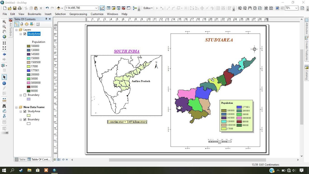
Create Map Layout in ArcGIS – Study Area Mapping
Показать описание
This Video helps in creating Map Layout in ArcGIS, a brief introduction to Map Layout for making study area map. Explains the following steps in map Layout:
1. Create Portrait and Landscape Map layout
2. Adjusting Map layout
3. Adding & customizing – Locator Map, North Arrow, Scale bar, Neat line and Legend
4.Creating Latitude and Longitude layout view
5. Insert Map and Extent Indicator
1. Create Portrait and Landscape Map layout
2. Adjusting Map layout
3. Adding & customizing – Locator Map, North Arrow, Scale bar, Neat line and Legend
4.Creating Latitude and Longitude layout view
5. Insert Map and Extent Indicator
 0:08:38
Make a layout in ArcGIS Pro
 0:17:14
Study Area Mapping | Create Map Layout in ArcGIS
 0:08:23
How to Make Map Layout in GIS || Map Layout in ArcMap || Create Map Layout in GIS
 0:18:36
Create Map Layout in ArcGIS – Study Area Mapping
 0:10:58
Creating a Simple Map Layout in ArcGIS Pro
 0:19:09
Create study area map in ArcGIS - Map Layout in ArcMap
 0:14:56
How To Make Study Area Map in ArcGIS. Complete Process. #arcgis #studyareamap #civilengineering
 0:16:33
How to prepare Multiple Maps in ArcGIS with single layout
 0:20:20
Arcgis tutorial | Creating map layouts in ArcGIS Pro
 0:09:46
ArcGIS Create A Map Layout
 0:17:05
Mastering Map Layouts in ArcGIS Pro | A Step-by-Step Tutorial | Beginners
 0:07:01
Creating a map layout in ArcGIS Pro
 0:04:56
Making and Exporting Maps in ArcGIS Pro
 0:18:22
Preparing Study Area Map in ArcGIS | Create Map Layout
 0:33:37
Creating Professional Map Layout in ArcGIS Pro | Template for any Study Area|@LatLongCoder
 0:09:39
A Complete Beginner's Guide to ArcGIS Pro: Part 1
 0:37:26
How to Make a Map in ArcGIS
 0:31:18
Creating a Map using ArcGIS (A step-by-step guide)
 0:15:10
Location Map Preparation in Arc GIS | Layout Preparation
 0:02:59
16 - How to create a simple map layout in ArcGIS 10.2.2
 0:00:56
Add guides to a layout in ArcGIS Pro
 0:03:03
QuickDemo: Adding an Inset Map and Extent Indicator
 0:41:36
Making a Map using ArcGIS Pro
 0:12:53
ArcGIS Pro Tutorial: Creating a Map Layout in ArcGIS Pro
Комментарии