filmov
tv
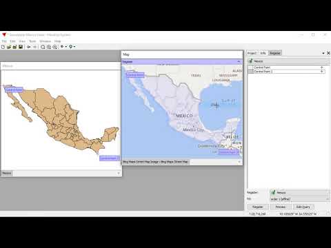
Georeferencing in 5 Minutes in ArcGIS | ArcMap

Показать описание
From Beginner to Master of Georeferencing in 5 minutes in ArcMap.
Georeferencing is a process used in geographic information systems (GIS) and cartography to assign real-world geographic coordinates (latitude and longitude) to spatial data that does not originally have such coordinates. It involves aligning or "referencing" data to specific locations on the Earth's surface, allowing it to be accurately positioned and integrated with other geographic information.
To digitize a Scanned Map or Raster Image in ArcMap, Georeferencing is the image or scanned map is a precondition.
In this video, the process is explained in the simplest way.
_____________________________________________________________________
_____________________________________________________________________
This playlist on the applications of ArcMap (ArcGIS Software) will enrich your basic and practical knowledge on Geographic Information Systems (GIS).
_____________________________________________________________________
Free Materials:
_____________________________________________________________________
I will sequentially upload videos on numerous ArcGIS applications so that you can master on Geospatial Analysis.
_____________________________________________________________________
Related Tags: #georeferencing #gis #arcgis #arcgistutorial #arcmap #projection #spatialdata #spatialanalysis #remotesensing #coordinatesystem #georeference #geography #englishtutorial #easytutorial #easytutorialsforbeginners #digitize #digitization #digitizing #GIS #GeographicInformationSystem Muhammad Al Amin #Geospatial Navigators
 0:05:55
Georeferencing in 5 Minutes in ArcGIS | ArcMap
 0:06:12
Georeferencing in ArcGIS Pro in 5 Minutes: Rubbersheeting
 0:06:05
Georeferencing in ArcGIS Pro in 5 Minutes: Control Points
 0:05:20
Georeferencing with Arcgis Pro in 5 minutes
 0:31:21
Georeferencing: Using Known Coordinates
 0:07:07
5 Minute Tutorial - Georegistration
 0:08:11
5 minute Tutorial - Georeference Many CAD Layers
 0:08:37
Step 2b: Georeferencing using x y values
 0:03:48
Georeferencing JPEG/JPG Image Map or Scanned Map in ArcGIS
 0:23:21
Georeferencing an Image or a Scanned Map using ArcGIS Pro
 0:00:57
One Minute Map Hack: Georeference Images to Give them Spatial Life
 0:05:31
Georeferencing in ArcGIS Pro
 0:05:23
How to Georeference image using ArcMap
 0:10:01
Free Download GIS Data for any Country just in 5 minutes
 0:04:58
Georeferencing Using GCP in ArcGIS10.4.1
 0:04:26
QGIS Quick Tip: Georeferencing
 0:22:52
How to Use QGIS Software | Georeferencing in QGIS ~ SESSION_3
 0:14:28
Georeferencing using link table method
 0:31:38
How to geo-reference a map or image using Google Earth Pro.
 0:00:33
Georeferencing a map graphic to ortho imagery
 0:03:11
2. How to do Georeference, using GCP
 0:06:18
Module 1: What is georeferencing? [Georeferencing in CCH2 Training Course]
 0:01:46
GIS: Georeferencing transformation types (2 Solutions!!)
 0:01:27
Direct Georeferencing for UAVs
Комментарии