filmov
tv
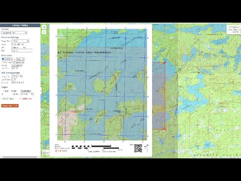
MAKE CUSTOM BACKCOUNTRY MAPS for AVENZA MAPS // Make offline maps using Caltopo to use in Avenza

Показать описание
Avenza Maps is a powerful navigation app for hikers to use offline maps. It uses Geospatial PDFs, GeoPDFs, or GeoTIFF to create offline maps for route navigation. In this video, I show you how to make your own Geospatial PDFs using Caltopo and how to import it into Avenza Maps. We take it a step further to create KML/GPX layers and link them to high resolution, free USGS maps.
—
—
 0:10:51
How I Create Custom Print Maps for the Backcountry
 0:14:37
MAKE CUSTOM BACKCOUNTRY MAPS for AVENZA MAPS // Make offline maps using Caltopo to use in Avenza
 0:12:22
Make Your Own FREE Backcountry Maps with CalTopo
 0:14:57
Find, Buy, and Print Your Own Topo Maps
 0:03:07
How to Make Your Own 1:25000 Printable Topo/Military Map.
 0:05:59
How to Make Your Own Maps | Outside
 0:21:18
Creating Custom Maps with CalTopo
 0:15:12
ORDER, PRINT, AND MAKE YOUR OWN TOPO MAPS!
 0:21:50
CALTOPO TUTORIAL // Backcountry Mapping Made Easy
 0:10:32
How To Create Custom Maps with AllTrails Pro - Routes and Waypoints
 0:11:11
HOW TO WATERPROOF MAPS // DIY Waterproof Maps for Hiking and Backpacking
 0:03:36
Custom Maps are back on the MyTopo Website!
 0:00:25
Trailer to Making Your Own Topographic Route Map for Mountaineering, Backpacking, and Hiking #Shorts
 0:38:12
Basic Land Navigation - Part 3: CalTopo for FREE Custom Topographic Maps!
 0:15:14
AVENZA MAPS TUTORIAL // How to find and import maps, create features, and use GPS Functions
 0:10:32
How to use CalTopo Backcountry Maps (Tutorial and Tips for planning a backcountry trip)
 0:13:01
On Demand, Custom, Topographic Maps with topoBuilder - Alexander Kaufman, U.S. Geological Survey
 0:04:23
Making Custom Trail Maps for Horse Trails and Everything Else
 0:07:51
How-To Make a Map Case for Wilderness Adventure Trips - Storing Your Topographic Maps in the Field
 0:00:41
Plan Your Next Hike in 3D with onX Backcountry
 0:00:35
Google Earth Pro: The Ultimate Backcountry Hunt Planning Tool
 0:12:52
AVENZA MAPS On the Trail // How to use Avenza Maps while hiking
 0:08:08
Backcountry Navigator video #2, How to create a waypoint and record a track.
 0:04:14
How to use Google Maps on Hiking Trails Even Without Cell Service
Комментарии