filmov
tv
QGIS 2 Lesson 7 - Beginning some basic habitat modelling

Показать описание
Hi and welcome to the seventh lesson in DMAD - Marine Mammals Research Association's second free QGIS course. This course if for beginners to intermediates. In this lesson we look at some very, very habitat modelling using the buffer tool and proximity to water. We'll extend our habitat modelling over the upcoming lessons.
 0:05:57
QGIS 2 Lesson 7 - Beginning some basic habitat modelling
 0:01:27
Part A Chapter 2 Lesson 7 An introduction to QGIS
 0:04:08
GIS 300 Week 7 Part 2: Profile tool in QGIS for existing line
 0:04:05
QGIS Application Lesson 7 (Interpolation)
 0:27:33
How to digitize in QGIS # Lesson 7 of 29 # QGIS Tutorial
 0:24:26
GIS Lesson 7 4 b: Interpolation Techniques in QGIS
 0:05:06
QGIS Lesson 7 - Adding Background Mapping Using xyz Tiles
 0:10:37
QGIS Lesson 7: Creating a point, line and polygon shapefile from a basemap | tutorial video
 0:05:14
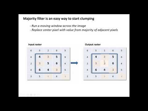
Clumping Pixels with the Majority Filter in QGIS 3.10 (lab 7- V2)
 0:06:25
FOR 242 Week 7 Part 4: Profile tool plugin for QGIS 3.16
 0:12:13
QGIS 3 Lesson 7 - Other examples, installing plugins and querying our raster
 0:17:22
QGIS Layout Design - Part 7 Lines 2 Polygons
 0:14:29
7. Download Satellite Images inside QGIS
 0:05:30
Layer Stack in QGIS [Sentinal-2, Landsat-5,6,7,8 & others 100% working] No Plugin required
 1:12:46
Learn GIS - QGIS Full Course for Beginners (New for 2024)
 0:00:45
How to Convert #raster Image into Vector or into #lineart in Coreldraw #shorts #coreldraw #design
 0:25:15
GIS 300 Week 7: Viewshed analysis of a trail in QGIS 3.16
 0:05:53
QGIS Tutorials 7: How to Add & use Multiple Map Canvases in QGIS | New Map View | Beginners
 0:05:06
QGIS 7 Creating Vector Point Data From CSV File
 0:02:07
QGIS Quick Tip 6 Making buffers look nicer
 0:00:16
Do you want to better your life? #philippines #angelescity #expat #pampanga #travelvlog
 0:01:19
GIS: Using SAGA GIS 7.X modules in QGIS (2 Solutions!!)
 0:05:47
GIS Lesson 3 2 c: Geometry Generator Style in QGIS
 0:06:54
QGIS Course 2 Lesson 4 - Coordinate Reference Systems Part 2 Distortions in coordinates sytems
Комментарии