filmov
tv
Complete Beginner's Guide to ArcGIS Desktop-part 2

Показать описание
Complete Beginner's Guide to ArcGIS Desktop-part 2
Welcome to this Complete Beginner's Guide to ArcGIS Desktop tutorial part 2. Through this tutorial, I want to give you a very deep understanding of what ArcGIS Desktop can do if you are starting out as a beginner. ESRI's ArcGIS has been around for quite some time and despite competition from so many other commercial and open-source GIS tools, it remains one of the most widely used GIS software packages in so many different fields today; such as the health sector, transport, and shipping, water resources engineering, geological sciences, you name it. The presentation outline is below
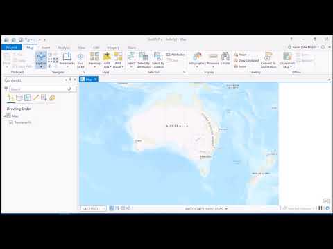
a. How to add base maps
A basemap provides a background, or visual context, for the data in a map. ArcGIS includes several types of base maps that you can use in ArcGIS for Office, including aerial imagery, terrain, streets, and topographic data. The default basemap displayed on the map is determined by your ArcGIS administrator.
• zoom in and zoom out
• edit the base map
• cut polygons
b. Calculating geometrical properties from shapefiles. How to calculate geometrical properties (area, length etc.) To calculate the geometric properties such as area, you need to reproject the vector data.
Area: To calculate area, you need to change the geographic coordinate system to a projected coordinate system to deactivate area function.
a. Go to google earth to find out the particular zone in which you are in (tools-options-UTM. Secondly go to argis and move to project-projected coordinate systems-UTM-WGS 1984-zone 30N
• Perimeter
• length
• Using measure tool
• calculate y and X midpoint
• calculate Y and X coordinates
c. Digitizing and creating your own shapefiles.
a. Digitizing-go to your folder in a catalog-right click -new-shapefile.
b. name it and choose a particular shape (polygon, polyline).
c. be in editor mode and click on create features
d. save edits and stop editing
e. open attribute table, add field, start editing and add the name of the feature
d. How to export vector data as an ESRI Shapefile
e. How to export vector data into ESRI shapefile and Google Earth (.kmz format)
Welcome to this Complete Beginner's Guide to ArcGIS Desktop tutorial part 2. Through this tutorial, I want to give you a very deep understanding of what ArcGIS Desktop can do if you are starting out as a beginner. ESRI's ArcGIS has been around for quite some time and despite competition from so many other commercial and open-source GIS tools, it remains one of the most widely used GIS software packages in so many different fields today; such as the health sector, transport, and shipping, water resources engineering, geological sciences, you name it. The presentation outline is below
a. How to add base maps
A basemap provides a background, or visual context, for the data in a map. ArcGIS includes several types of base maps that you can use in ArcGIS for Office, including aerial imagery, terrain, streets, and topographic data. The default basemap displayed on the map is determined by your ArcGIS administrator.
• zoom in and zoom out
• edit the base map
• cut polygons
b. Calculating geometrical properties from shapefiles. How to calculate geometrical properties (area, length etc.) To calculate the geometric properties such as area, you need to reproject the vector data.
Area: To calculate area, you need to change the geographic coordinate system to a projected coordinate system to deactivate area function.
a. Go to google earth to find out the particular zone in which you are in (tools-options-UTM. Secondly go to argis and move to project-projected coordinate systems-UTM-WGS 1984-zone 30N
• Perimeter
• length
• Using measure tool
• calculate y and X midpoint
• calculate Y and X coordinates
c. Digitizing and creating your own shapefiles.
a. Digitizing-go to your folder in a catalog-right click -new-shapefile.
b. name it and choose a particular shape (polygon, polyline).
c. be in editor mode and click on create features
d. save edits and stop editing
e. open attribute table, add field, start editing and add the name of the feature
d. How to export vector data as an ESRI Shapefile
e. How to export vector data into ESRI shapefile and Google Earth (.kmz format)
 1:00:57
 1:24:42
 0:09:39
 0:44:10
 0:49:44
 0:13:21
 0:09:49
 1:19:19
 0:10:10
 0:17:02
 0:10:03
 1:13:06
 0:57:06
 0:28:41
 0:00:19
 0:27:22
 1:59:53
 0:11:35
 0:10:23
 1:01:42
 0:51:59
 0:14:56
 0:22:33