filmov
tv
Georeferencing Topographic Map Image or Scanned Topographic Map Using ArcGIS

Показать описание
This Tutorial Video shows How to Georeference | Project (Georeferencing) a Map Image or a Scanned Map using ArcGIS – ArcMap with application to San Francisco North Topographic Map.
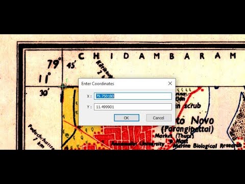
The San Francisco North Topographic Map formatted to “.jpg” Raster Image has been chosen for ArcGIS Georeferencing following a step by step method: - Document Preparation - Georeferencing: 1. Define Projection; 2. Add Control Points - Check Projection - Save To LayerFile.
This Tutorial helps to Georeference | Project (Georeferencing) a Non-Georeferenced Image Raster (JPEG, TIFF, BMP, PNG …) to a Georeferenced Raster File (TIFF, BMP, ENVI, BIL …).
This ArcGIS Tutorial provides also detailed Information about Spatial Reference | Coordinate System | Projection.
- - Link to DATAlyse Channel: Like and Subscribe
- - Link to DATAlyse ArcGIS tutorials Playlist:
- - Link to DATAlyse Analysis and processing of precipitation data Series Playlist:
- - Donation | Contact:
To support our channel please donate on our paypal account (mail contact) and If you need some custom work or supplementary information, contact us:
- - -
- Link to Topographic Map used in this video (San Francisco North):
Acknowledgment to the U.S. Geological Survey for Topographic Map product (CA_San_Francisco_North_20180914_TM_geo).
- - -
- Music Track:
Music promoted by Audio Library
- - -
On This DATAlyse ArcGIS tutorials Playlist You Can Find:
ArcGIS, ArcGIS Tutorials, ArcMap, Georeferencing, Spatial Reference, Projection, Topographic Image Map, Scanned Topographic Map, Raster Image, Conversion, Cartography, GIS.
- - -
Stay tuned as more Tutorial videos will be released in the coming weeks and months.
For more: Follow, Like, Share and Subscribe.
Thanks For Watching.
 0:06:24
 0:17:32
 0:03:48
 0:05:41
 0:12:17
 0:23:21
 0:10:31
 0:18:12
 0:08:37
 0:27:22
 0:04:26
 0:15:44
 0:20:42
 0:17:50
 0:10:02
 0:10:18
 0:12:11
 0:03:44
 0:07:44
 0:07:16
 0:11:53
 0:04:17
 0:06:33
 0:03:25