filmov
tv
Georeferencing a Scanned Topographic Map using QGIS

Показать описание
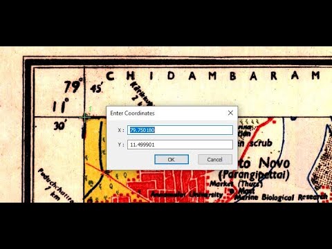
In this video, you will learn how to use the Georeferencer tool of QGIS to assign the correct geographic information to a scanned topographic map.
Georeferencing is the process of defining the existence of a certain geographic object in physical space by assigning the actual coordinate properties to the object, considering a specific coordinate reference system.
Typically objects like aerial photos or scanners maps, when found in file formats such as JPEG, PNG, do not contain any geospatial properties in them. This means, if you were to drag the image and drop it in a GIS software like QGIS or ArcGIS, it would not be placed where its supposed to be due to the fact that no specific coordinate values have been assigned for any of the pixels of the image.
Therefore, the process of taking a raw image and transforming it into an image which consists of the aforementioned geospatial properties is the core technique that is discussed in this tutorial. As the raw image, a scanned topographic map was used for the purposes of this tutorial as it originally did not contain any coordinate reference properties.
You may also check out the following videos that are related to this tutorial:
#georeferencing #qgis #geodeltalabs
 0:17:32
Georeferencing a Scanned Topographic Map using QGIS
 0:06:24
Georeferencing Topographic Map Image or Scanned Topographic Map Using ArcGIS
 0:19:28
Georeferencing a Scanned Topographic Map using ArcGIS
 0:05:41
Georeference Scanned Topographic Map Using QGIS - Made Simple & Easier
 0:10:02
How to digitize automatic a scanned topographic map with ArcGIS
 0:27:22
Georeference Scanned Topographic Map Using QGIS - Simplified
 0:03:48
Georeferencing JPEG/JPG Image Map or Scanned Map in ArcGIS
 0:23:21
Georeferencing an Image or a Scanned Map using ArcGIS Pro
 0:10:31
How to Georeference a Scanned Topographical Map in QGIS @GISRSSolution @pattrawuth #gis
 0:20:42
How to Geo-reference and recreate a topo map in Arcgis
 0:04:34
How to Georeference a Scanned Map
 0:10:31
Georeference a topographic map in QGIS (Version 3.x)
 0:07:51
Geo-referencing Topo Sheets and Scanned Maps
 0:09:19
How to Digitizing Scanned Topographic Map Using ArcGIS.
 0:18:12
How to Geo Referencing of Topographical Map in QGIS
 0:03:06
how to georeference a scanned map using arcgis software
 0:06:33
How do I georeference a Topographical Map in Qgis? Quick Guide #QGIS #Georeferencing #GIS
 0:12:17
Georeferencing topo map with projected coordinates
 0:14:37
Georeferencing a scanned map in ArcGIS Desktop.
 0:10:01
How georeferencing a scanned map in ArcGIS 9.3
 0:13:10
ARCGIS (GEOREFRENCING)
 0:07:16
How to do Geo referencing the Toposheets in Arc GIS
 0:07:07
Georeference a Scanned Map in QGIS
 0:07:44
Georeferencing a SOI Toposheet in ArcGIS Software
Комментарии