filmov
tv
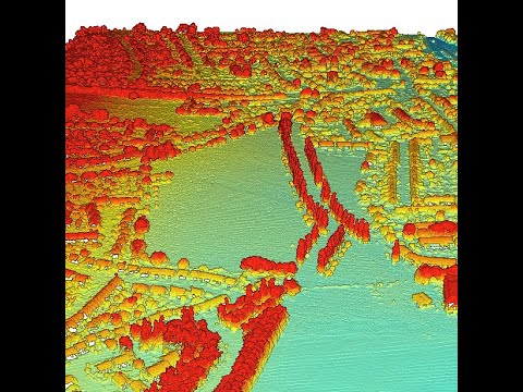
LiDAR Data Processing in ArcGIS (LAS Dataset)

Показать описание
ArcGIS supports lidar data provided as LAS (or ASCII) files. There are three different formats (datasets) that can be used to manage and work with your lidar data in ArcGIS depending on your needs, which include the LAS dataset, terrain dataset, and mosaic dataset.
The LAS dataset provides fast access to large volumes of lidar and surface data without the need for data conversion or importing. It makes it easy to work with several thousand LAS files covering an entire administrative area or perhaps just a few LAS files for a specific study area. It allows you to examine LAS files quickly, providing detailed statistics and area coverage of the lidar data in the LAS files.
A LAS dataset can be:
➡ Used in ArcGIS in both 2D and 3D using ArcMap and ArcScene.
➡ Displayed as either points using elevation or point attribute renderers based on certain lidar filters applied to the point cloud.
➡ Rendered as a triangulated surface model.
➡ Visualized using elevation, slope, aspect, or contour lines based on certain lidar filters.
➡ Used to make updates to the source LAS files.
____________________________________________
✅ in the previous video we've shown how to process lidar point Cloud in the ENVI. in this video We've recorded a video and shown you to process LAS dataset in the ArcGIS.
_____________________________________________
🔴 Check it out:
Subscribe to our channel and Like the video:
_ _ _ _ _ _ _ _ _ _ _ _ _ _ _ _ _ _ _ _ _ _
Share the video with others:
=========================================================
 0:07:57
LiDAR Data Processing in ArcGIS (LAS Dataset)
 0:03:13
LiDAR processing on ArcGIS
 0:09:30
LIdar Data processing ArcPro
 0:12:59
Processing LiDAR data using ArcGIS Pro
 0:08:18
LIDAR Data Processing
 0:04:27
lidar&remote sensing 3: arcgis pro lidar data processing(dem/dsm/visibility)
 0:00:27
Lidar Point Cloud - Ground Classification
 0:13:57
Working with Lidar Data || How to Create DEM in ArcGIS
 0:04:44
LIDAR Point Clouds Editing and Manipulation in ArcGIS Pro
 0:08:45
Vegetation Forest Canopy Cover Estimation Using LIDAR/Photogrammetric Point Clouds Data and ArcGIS
 0:10:10
LiDAR Surface Models in ArcGIS Pro
 0:06:59
How to Load and View Lidar in ArcGIS Pro
 0:15:47
Working with LiDAR Data in ArcGIS Pro
 0:11:26
How to Create a DEM using LIDAR data.
 0:27:28
Exploring a LiDAR LAS dataset in ArcGIS Pro
 0:02:13
Quickly displaying LiDAR LAS dataset in 3D in ArcMap 10.6.1
 0:08:56
Chapter 13: Visualizing Lidar Data in ArcScene
 0:08:25
Chapter 10 - Setting up ArcGIS Pro for Lidar data
 0:41:12
Downloading Using and Analyzing Lidar Data in ArcGIS Pro
 1:05:58
Using LiDAR and ArcGIS Pro - Geospatial Tools and data
 0:07:23
RS.Lab3 - Processing Lidar data
 0:10:00
HOW TO BUILD LOD2 3D BUILDING DATA USING LIDAR POINT CLOUD DATA IN ARCGIS PRO
 0:04:26
Measuring LiDAR Data in ArcGIS Pro
 0:00:25
Lidar Point Cloud - Classify by Height
Комментарии