filmov
tv
Geospatial epidemiology of disease spread in Malaysia | Stay at Home | Hotspot analysis

Показать описание
#spss #kajidataonline #pkp #ppkp #ministryofhealth #ilkkm #kkm #stayathome
Thanks for visiting our video. This platform helps you in data analysis and making the decision based on statistical analysis/ data analysis technique. Our online platform are fully FREE and please do Subscribe and Follow us. We offer free workshop and virtual workshop for data analysis applications in:
1) Medical sciences
2) Epidemiology
3) Information technology
4) Geostatistics
5) Machine Learning and Artificial Intelligent
6) Many more
Checking out our Other Workshop Here:
Subscribed Our Channel:
Learn How to Analyze data by visiting our website:
Latihan Software, Biostatistic dan Epidemiologi kepada Anggota KKM/ Swasta sila hubungi kami:
Do not forget to LIKE, SUBSCRIBE and FOLLOW Our Facebook Channel:
Buy Online Ticket for Learning SPSS and Other Statistical Tools
-Admin Kajidataonline-
 0:14:14
Geospatial epidemiology of disease spread in Malaysia | Stay at Home | Hotspot analysis
 0:34:03
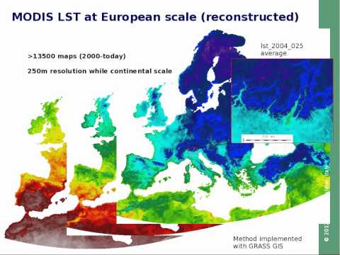
Geospatial risk models for tropical disease mapping
 0:02:35
Mapping Epidemics: Why Maps + Disease
 0:10:16
Spatial Epidemiology Disease Spread Yearly to another location
 0:19:45
Spatial Epidemiology with Open Source GIS
 0:03:07
#2 Geospatial and temporal data analysis for applied epidemiology and outbreak in QGIS
 0:07:12
How to produce heatmap in epidemiology using qgis free geospatial software in Applied Epidemiology
 0:21:29
Geospatial Revolution: Mapping the Pandemic
 0:52:52
'Global maps of the spread of infectious diseases and their vectors' with Dr Moritz Kraeme...
 0:15:10
Hotspot Analysis Epidemiology | Geospatial data analysis spread of disease in QGIS
 0:59:32
Infectious Disease Surveillance and Modeling through Spatial Big Data
 0:01:09
EPI 563: Concepts and Applications in Spatial Epidemiology
 0:02:27
Geospatial Epid 12 - Application of spatial epidemiology in disease
 0:19:45
Spatial Epidemiology with Open Source GIS
 0:03:58
#1 Spatial epidemiology | disease mapping temporal technique identification | managing outbreak qgis
 0:15:08
Mapping for Early Warning Sensing Systems for Infectious Diseases by Mengdie Zhuang
 0:55:03
Disease Mapping and Epidemiology with COVID 19 | Zizouz212
 0:12:44
CDC NERD Academy Student Quick Learn: How is an outbreak investigated?
 0:57:02
Modeling COVID-19 Using Spatial Modeling and Simulation – Ingenious Talks
 0:50:09
Spatial Epidemiology in Communicable Diseases
 1:19:10
Topic: Spatial Epidemiology: Research Challenges and Future Opportunities for Prediction of Diseases
 0:59:20
Geospatial Forum: Dr. Peter Ojiambo
 0:29:37
Mapping the zoonotic niche of Ebola virus disease in Africa
 0:00:50
AXA Award - Modelling the Spatial Spread of Infectious Diseases -Dr Simon Cauchemez (France)
Комментарии