filmov
tv
Masking/filtering soil pixels from drone imagery in QGIS (Drones in agriculture series, 4/7)

Показать описание
To determine health and size of plant canopies, it is important to remove soil values. This video covers how to eliminate soil pixels from drone data, so they do not influence vegetation indices and other data.
If you found these methods useful, please consider citing our recent paper in the journal Remote Sensing:
Parker, T. A., Palkovic, A., & Gepts, P. (2020). Determining the Genetic Control of Common Bean Early-Growth Rate Using Unmanned Aerial Vehicles. Remote Sensing, 12(11), 1748.
If you found these methods useful, please consider citing our recent paper in the journal Remote Sensing:
Parker, T. A., Palkovic, A., & Gepts, P. (2020). Determining the Genetic Control of Common Bean Early-Growth Rate Using Unmanned Aerial Vehicles. Remote Sensing, 12(11), 1748.
 0:04:39
Masking/filtering soil pixels from drone imagery in QGIS (Drones in agriculture series, 4/7)
 0:15:16
Calculating vegetation indices & plant/soil separation with QGIS (Drones in agriculture series, ...
 0:13:04
How to delineate crops from Drone Orthophotos with QGIS - Tutorial
 0:00:28
This can happen in Thailand
 0:00:07
which side are you on? 🇮🇱/🇵🇸 #israel #freepalestine #idf #shortsvideo
 0:00:16
Testing Stable Diffusion inpainting on video footage #shorts
 0:00:05
Don't make eye contact
 0:21:11
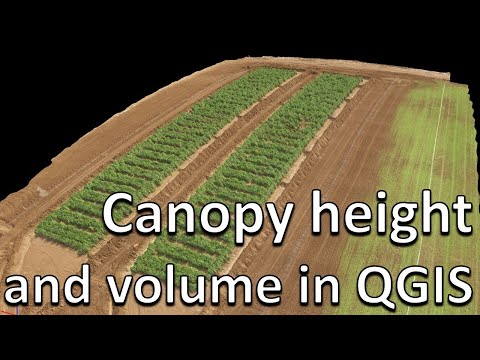
How to measure canopy height and volume using QGIS (Drones in Agriculture series, 6/7)
 0:01:19
GIS: Masking cloud pixels for NDVI in QGIS
 0:24:37
Using QGIS to Segment Orthomosaics and Extract Drone Data
 0:00:17
Fork mounted razor machetes! #mtb #mountainbike #shorts
 0:29:00
How to separate plots and extract plot data using QGIS (Drones in agriculture series, 5/7)
 0:01:56
GIS: Mask pixel values in Raster image QGIS (2 Solutions!!)
 0:00:15
Cosplay by b.tech final year at IIT Kharagpur
 0:00:40
Massive and Terrifying Spider Discovered (Must See) Scary Comp
 0:00:37
It's getting rough out here :( #shorts
 0:06:05
Tutorial - Vineyard Visual Inspections using NDVI Indexes from a drone.
 0:07:51
Tutorial PIX4Dfields: Trial Plot Analysis & Statistical Comparison with Multispectral Imagery
 0:01:00
His reaction when he sees her FEET for the first time…😳 #Shorts
 0:05:00
How to use drones (UAVs) in agriculture and plant science (Drones in agriculture series intro, 1/7)
 0:05:09
Multispectral to true-color RGB drone imagery (Drones in agriculture series 7/7)
 0:01:45
GIS: Filtering a raster by pixel value s (Qgis)
 0:14:11
Geospatial crop counting from drone orthophotos with Python and Scikit Learn
 0:00:14
😂#happyvishu #padakkam #funny #trending #viralvideo #subscribe #fifa #vairalvideo
Комментарии