filmov
tv
Create HEC DSS File for Parameters in HEC GEO HMS, Gridded option 16 of 19

Показать описание
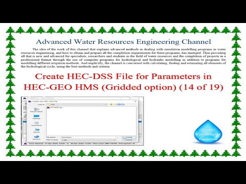
Create HEC DSS File for Parameters in HEC GEOHMS, Gridded option
HEC-GeoHMS is a GIS extension that provides the user with a set of procedures, tools, and utilities for the preparation of GIS data for import into HEC-HMS and generation of GIS data from HMS output.
The Geospatial Hydrologic Modeling Extension (HEC-GeoHMS) has been developed as a geospatial hydrology toolkit for engineers and hydrologists with limited GIS experience. HEC-GeoHMS uses ArcGIS and the Spatial Analyst extension to develop a number of hydrologic modelling inputs for the Hydrologic Engineering Center's Hydrologic Modeling System, HEC-HMS. ArcGIS and its Spatial Analyst extension are available from the Environmental Systems Research Institute, Inc. (ESRI). Analyzing digital terrain data, HEC-GeoHMS transforms the drainage paths and watershed boundaries into a hydrologic data structure that represents the drainage network. The program allows users to visualize spatial information, document watershed characteristics, perform spatial analysis and delineate subbasins and streams. Working with HEC-GeoHMS through its interfaces, menus, tools, buttons, and context-sensitive online help allows the user to expediently create hydrologic inputs for HEC-HMS.
Chapters:
00:00 The title
00:35 Continuing to explain the method of Creating an HEC-DSS File for the rest of the Parameters in HEC-GEO HMS
04:51 How to create the HEC-DSS File for the GW1COEFF1, and GW2COEFF2 parameters?
HEC-GeoHMS is a 2D/3D mapping software for land, water, and airborne surveys.
Introducing HEC-GeoHMS. A high-quality education in the field of sustainable development, global health, and international affairs.
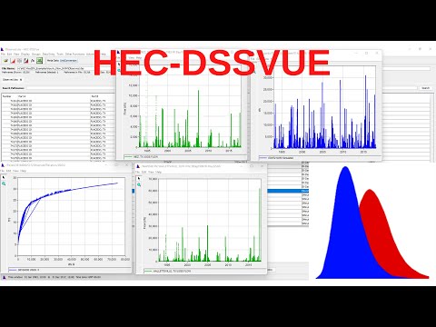
HEC-DSSVue is a Java-based visual utilities program that allows users to plot, tabulate, edit, and manipulate data in a HEC-DSS database file. The graphics produced by HEC-DSSVue are highly customizable and can be saved in various formats, including "jpeg" and "png" (portable network graphics), or for printing or copying to the clipboard for inclusion in reports. HEC-DSSVue incorporates over sixty mathematical functions. Along with these functions, HEC-DSSVue provides several utility functions that provide a means to enter data sets into a HEC-DSS database, rename data set names, copy data sets to other HEC-DSS database files, and delete data sets.
Download HEC-GeoHMS from the following Website link
Download HEC-DSSVue from the following Website link
Channel Website link
Channel page Website link
Website
#Advanced_Water_Resources_Engineering
#HEC_GeoHMS
#HEC_HMS
#HEC
#HMS
#HEC_HMS_GRIDDED
#HEC_HMS_CALIPRATION
#HEC_HMS_OPTIMIZATION
#RESERVOIR
#ArcGIS
#DAM
#Dem
HEC-GeoHMS is a GIS extension that provides the user with a set of procedures, tools, and utilities for the preparation of GIS data for import into HEC-HMS and generation of GIS data from HMS output.
The Geospatial Hydrologic Modeling Extension (HEC-GeoHMS) has been developed as a geospatial hydrology toolkit for engineers and hydrologists with limited GIS experience. HEC-GeoHMS uses ArcGIS and the Spatial Analyst extension to develop a number of hydrologic modelling inputs for the Hydrologic Engineering Center's Hydrologic Modeling System, HEC-HMS. ArcGIS and its Spatial Analyst extension are available from the Environmental Systems Research Institute, Inc. (ESRI). Analyzing digital terrain data, HEC-GeoHMS transforms the drainage paths and watershed boundaries into a hydrologic data structure that represents the drainage network. The program allows users to visualize spatial information, document watershed characteristics, perform spatial analysis and delineate subbasins and streams. Working with HEC-GeoHMS through its interfaces, menus, tools, buttons, and context-sensitive online help allows the user to expediently create hydrologic inputs for HEC-HMS.
Chapters:
00:00 The title
00:35 Continuing to explain the method of Creating an HEC-DSS File for the rest of the Parameters in HEC-GEO HMS
04:51 How to create the HEC-DSS File for the GW1COEFF1, and GW2COEFF2 parameters?
HEC-GeoHMS is a 2D/3D mapping software for land, water, and airborne surveys.
Introducing HEC-GeoHMS. A high-quality education in the field of sustainable development, global health, and international affairs.
HEC-DSSVue is a Java-based visual utilities program that allows users to plot, tabulate, edit, and manipulate data in a HEC-DSS database file. The graphics produced by HEC-DSSVue are highly customizable and can be saved in various formats, including "jpeg" and "png" (portable network graphics), or for printing or copying to the clipboard for inclusion in reports. HEC-DSSVue incorporates over sixty mathematical functions. Along with these functions, HEC-DSSVue provides several utility functions that provide a means to enter data sets into a HEC-DSS database, rename data set names, copy data sets to other HEC-DSS database files, and delete data sets.
Download HEC-GeoHMS from the following Website link
Download HEC-DSSVue from the following Website link
Channel Website link
Channel page Website link
Website
#Advanced_Water_Resources_Engineering
#HEC_GeoHMS
#HEC_HMS
#HEC
#HMS
#HEC_HMS_GRIDDED
#HEC_HMS_CALIPRATION
#HEC_HMS_OPTIMIZATION
#RESERVOIR
#ArcGIS
#DAM
#Dem
 0:27:26
 0:31:02
 0:24:35
 0:45:37
 0:06:03
 0:14:57
 0:02:04
 0:03:01
 0:08:38
 0:06:59
 0:03:35
 0:10:44
 0:10:47
 0:08:13
 0:56:36
 0:12:01
 0:09:23
 0:28:00
 0:44:07
 0:06:36
 0:12:20
 0:28:45
 0:06:00
 0:06:59