filmov
tv
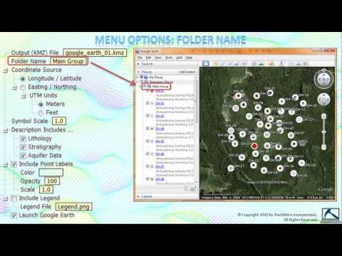
(RTR 3.2.1.4) Plotting Borehole Locations in Google Earth - Advanced

Показать описание
This video shows how to create a Google Earth map that depicts the locations for boreholes within the RockWorks database. It also shows how to set up Google Earth to display lithology, stratigraphy, and water-level data within Google Earth by simply clicking on a borehole symbol.
 0:07:26
(RTR 3.2.1.4) Plotting Borehole Locations in Google Earth - Advanced
 0:03:46
(RTR 3.2.1.3) Plotting Borehole Locations In Google Earth
 0:04:22
(RTR 3.1.3) Transferring Locations Between the Borehole Manager & Utilities Datasheet
 0:05:28
(RTR 3.0) Borehole Manager - Introduction
 0:04:16
(RTR 3.2.2.4) Computing Horizontal Borehole Paths
 0:07:35
(RTR 3.1.8) Depth-Registering Raster Logs & Other Images
 0:04:30
(RTR 3.2.2.1.2) Striplog Profiles
 0:06:04
(RTR 3.1.2) How To Create & Manage 'Sub-Sites'
 0:02:57
(RTR 3.1.4) Importing KGS (Kansas Geological Survey) Data
 0:03:45
(RTR 04.01.01.02) Symbol Map Options
 0:01:35
(RTR 3.2.2.10.1) Changes to the Stratigraphy Picker
 0:02:55
(RTR 1.5) Borehole Manager Introduction
 0:27:41
Borehole Logging Software - QuickLog Video 2 - Creating a Custom Format
 0:01:15
(RTR 3.2.1.1.1) Adding Peripheral Images To Maps
 0:02:12
Displaying Multiple Boreholes in a Borehole View
 0:05:19
(RTR 4.14.5) Draping Images Over Surfaces
 0:07:22
(RTR 4.16.3) Plotting Oil Leases
 0:02:34
(RTR 3.2.3.13.1) Converting Lithology to I-Data (e.g. Hydraulic Conductivity, Porosity)
 0:03:11
(RTR 3.2.2.1.1) 2-D Striplogs
 0:00:39
(RTR 2.1.1.2) Cumulative Gridding
 0:01:00
(RTR 2.1.1.1) Closest Point Gridding
 0:05:11
(RTR 4.16.2) Datasheet Input Coordinates
 0:00:49
(RTR 4.2.17.3) Converting Grids to Stratigraphic Quadrant Models
 0:03:35
(RTR 3.2.2.1.3) Creating Striplog Cross-Sections
Комментарии