filmov
tv
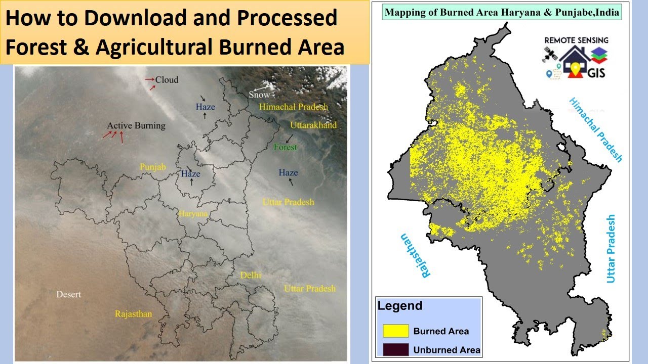
Mapping of Forest Fire & Agricultural Residues Burned Area part II
Показать описание
#forestfiremapping#agriculturalresidus#burnedarea#modisburnedproduct#MCD64A#forestfires
Hi, viewer In this tutorial, you will learn how to Mapping of Forest Fire & Agricultural Residues Burned Area
MODIS is a NASAs satellite with 36 spectral bands of various spectral ranges (405–14385 nm) and is used for a multitude of applications such as earth observation, vegetation monitoring, and environmental pollution assessment, among others. Details of bands and their applications may be obtained at
If you like this video, you can SUBSCRIBE to this channel to get new video updates on GIS & Remote Sensing. Thank you.
**How to download Forest Fire & Agricultural Residues Burned Area Data
Application of Forest Fire & Agricultural Residues Burned Area Data
Stubble burning is one of the major environmental hazards in all most all parts of the world. The problem is more intense in developing countries, especially in India, China, and Malaysia due to weather and topographic pattern. Agriculture mechanization to increase crop productivity and decrease labor costs in order to fulfill food security demands for its rapidly growing population is considered a key catalyst for stubble burning (Mehta et al., 2014). This may lead to a huge quantity of rice residues with a large potential for pollutant emissions after burning.
Typical applications include:
i) Mapping of Crop Residual Burning
ii) Mapping of Forest Fire
iii) Evapotranspiration models
iv) Climate Change modeling
v) Assessing Forest burned areas
vi) Find the variation in groundwater level due to Crop Residual Burning
vii) Vegetation Monitoring
Related Tags: how to download forest fire data, how to download agricultural burned area data, how to map forest fire, how to map crop residual burned area, how to download burned area data, how to download, satellite data, forest fires, wildfires, gis remote sensing, modis,
crop residues burned data, agricultural fire, forest fire mapping, agricultural fire mapping,
If you have any queries, Feel free to write me in the comment section. I'll try to answer all of your queries.
-----------------------------------------------------------------------------------------------------------------------
Join our Free Telegram Channel:
Facebook Page:
RS GIS HOME Facebook Groups:
Follow me on Linkedin:
===========================================================================
Playlists:
Geomatics Engineering Gate 2022 || Free Course:-
Remote Sensing and GIS tutorial:-
ArcGIS for beginners:-
ArcGIS Model Builder:-
Excel to ArcMap:-
Google Earth Pro:-
DGPS :-
Satellite Data Download:-
________________________________________________________________________
About the Channel:-
On this YouTube Channel:
Knowledge of Remote Sensing and GIS and how it works in the world
Videos and Lectures on Remote Sensing and GIS Techniques and their applications
A brief explanation of Practical Portion of GIS & Remote Sensing
Boost your concept with Remote Sensing and GIS
Keep yourself updated with the new techniques of Remote Sensing and GIS field
One-stop platform for Remote Sensing and GIS
Video Lectures & Study Material in Geomatics Engineering(GE for GATE)
So stay connected with us by just clicking on the Red Subscribe button and pressing the bell icon.
___________________________________________________________________________________
Reference
The presentation has been compiled from various sources such as books, tutorials (online and offline), internet. The information in this lecture /presentation is for general information and education purposes.
Thank You.
 0:13:40
Mapping of Forest Fire & Agricultural Residues Burned Area part II
 0:10:18
Forest Fire Damage Analysis Using Satellite Imagery and ArcGIS
 0:03:47
Yellowfang - Forest Fires [COMPLETED MAP]
 0:11:12
Google Earth Engine 40: Forest Fire Mapping with FIRMS Data | Fire Occurrence Data
 0:08:48
Google Earth Engine 41: Mapping Global Forest Fire using MODIS Burned Area
 0:00:59
Real Time Forest Fire Map (North America) #shorts
 0:00:09
Forest Fires MAP part 23
 0:00:53
These 3D mapping drones can help prevent forest wildfire
 0:12:30
Forest fire assessment using indices and change detection tool in ArcGIS Pro
 0:02:16
Using swarms of drones to map and help fight wildfires
 0:11:03
How to download Forest Fire & Agricultural Residues Burned Area Data part I
 0:01:47
Animated Maps: California Wildfires from 1910-2019
 0:01:53
First of its kind map shows wildfires burning in real time
 0:03:15
Google Earth Engine Advanced (Forest Fire detection)
 0:46:36
Susceptibility and risk modeling of forest fire using Geoinformatics
 0:20:04
How to Use NASA’s Fire Information for Resource Management System (FIRMS)
 0:02:45
Burn Severity Analysis Made Easy
 0:26:58
Preparing and using NASA Data in QGIS to Map Wildfire Impacts
 0:11:09
Calculate Normalized Burn Ratio Thermal (NBRT) using Earth Engine | Forest Fire
 0:58:39
NASA ARSET: Overview of the Global Wildfire Information System (GWIS), Part 2/2
 0:06:28
RS5.2 Forest land cover change mapping
 0:00:11
Forest fires are shifting north and intensifying
 0:10:29
How Fighting Wildfires Works
 0:04:45
How This Drone Will Save US Forests From Wildfires
Комментарии