filmov
tv
Module 3: Extracting tabular data from NetCDF climate files for use in other models and applications

Показать описание
ESCWA is organizing a virtual workshop series for government officials and researchers in the Arab region who are working in the area of climate change impact assessment and analysis using geospatial information system (GIS) tools, particularly in the water and agricultural sectors.
This third module presents guidance on how to extract time series or daily climate datasets from NetCDF files for use in different models and applications.
To find out more, visit our page here:
This third module presents guidance on how to extract time series or daily climate datasets from NetCDF files for use in different models and applications.
To find out more, visit our page here:

Module 3: Extracting tabular data from NetCDF climate files for use in other models and applications
Extract tabular data from PDF with Python - Tabula, Camelot, PyPDF2

Databricks Module 3(#15):Writing data to Delta Tables

Compare two Lists in Excel to find unique values | Filter and CountIf functions #shorts #excel

Gathering & Wrangling Data | Introduction to Data Science for Beginners (Module 3/5)

Combine Files from a Folder with Power Query the RIGHT WAY!

Module 3: Preparing and Cleaning Data for Analysis( Data Analytics- Excel, SQL, Tableau)

What is STAR schema | Star vs Snowflake Schema | Fact vs Dimension Table

Real Time Power BI Project, Blinkit Analysis #powerbi #powerbidashboard #dataanalyst

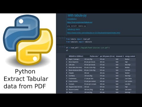
Python to Extract pdf Tables #shorts #python #finance

Excel IF function trick ( In 20 seconds)| Pass/Fail #shorts #exceltricks

It’s literally perfect 🫠 #coding #java #programmer #computer #python

I Create Excel file in 5sec using Python || python excel || python pandas || python to excel #python

Python tabula extract data from pdf file tutorial 2022

How to stack Enchanted books in Minecraft!

How to use VLOOKUP in Excel! #excel

Human Calculator Solves World’s Longest Math Problem #shorts

Excel tip to count how many times a name appears in a list
Separate pivot table columns #excel

Extracting tables from pdf with chatgpt
Shortcut to replace background color of multiple cells in excel | Quickly color cells formula

Extraction of unit level data of NSS- HCES (Module 3)

This is how to fix missing dll files to play games! 🔧🔎
How to make a pie chart in Google Sheets! 🥧 #googlesheets #spreadsheet #excel #exceltips
Комментарии