filmov
tv
How to calculate land surface temperature from Landsat 8 Satellite Data

Показать описание
Reference paper: Estimating Land Surface Temperature Using ArcGIS
Any Help Contact
WhatsApp Number= +918421031398
Special Thanks for What I am Using
you can refer this paper:- Estimation of Land Surface Temperature using LANDSAT 8 Data
Download Free Very High Aerial Imagery 0.5 meter, SRTM DEM,sentinel-2, Hyperion, LANDSAT-8 & Aster
How to calculate land surface temperature from Landsat 8 Satellite Data
How to Create LULC using ArcGIS/ Supervised Classification
How to Create coronavirus Map in ArcGIS !! Health GIS
Generate Contours and Slope From Google Earth in ArcGis
How to delineate watershed using DEM
Digitization in Arc GIS
georeferencing and projection
Download Very High Resolution Google Earth Image//Georeferencing in ArcGIS
No Copyright Music) Relaxing Background Music For Videos, Meditations, Yoga, Spa by AShamaluevMusic
(No Copyright Music) Relaxing and Meditation Background Music For Videos / Air by AShamaluevMusic
 0:10:31
How to calculate land area? #AREA-CALCULATION
 0:26:43
How to calculate land surface temperature from Landsat 8 Satellite Data
 0:03:30
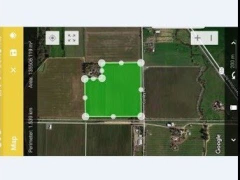
how to calculate land area ? | Google earth pro
 0:06:44
How to Calculate Land Area by Formula?
 0:02:27
How To Measure Land Area In Google Maps
 0:07:20
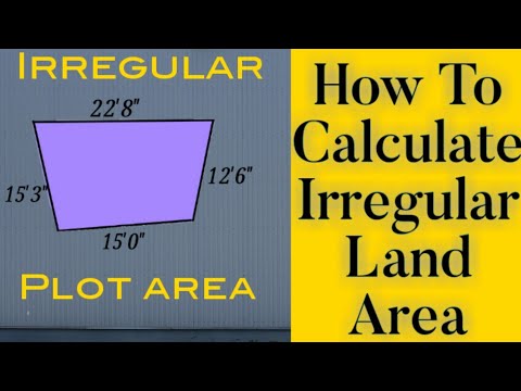
How to Calculate Area of Irregular Land or Plot Step by Step
 0:00:51
How To Measure Land Area In Google Maps?
 0:02:32
Measure your Land Area using App | How to Calculate Land Area | Land Measurement / Survey App
 0:12:18
Monitoring Drought Using Vegetation Health Index (VHI) in Google Earth Engine | Step-by-Step Guide
 0:10:46
Estimating Land Surface Temperature Landsat 8 | ArcGIS Tutorial |
 0:06:04
How To Calculate Irregular Land Area | Irregular Plot Area In Square Feet
 0:07:33
How to calculate Irregular land area// Irregular plot area in Square feet
 0:06:39
Calculating Land surface temperature using Landsat 8 Imagery || QGIS Tutorial
 0:15:34
How to Calculate Land Surface Temperature using Landsat8 in ArcMap 10.5
 0:02:04
CALCULATE AREA OF TRIANGLE
 0:26:43
How to calculate land surface temperature from Landsat 8 Satellite Data
 0:09:15
Calculate Land Surface Temperature Using Google Earth Engine || Time Series Analysis || MODIS || LST
 0:04:19
Measuring your property field using phone App
 0:04:33
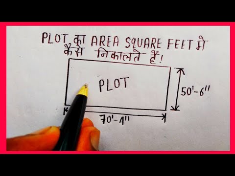
How to calculate land area || How to calculate land area in square feet || plot area calculation
 0:17:46
Calculating Land Surface Temperature Using Landsat 8 Imagery In ArcGIS || The GIS Hub || #LST #gis
 0:10:24
How to calculate Land Surface Temperature with Landsat 8 satellite images using Google Earth Engine
 0:02:34
Calculate Land Surface Temperature with Model Builder in ArcGIS.
 0:02:31
How to calculate Land Surface Temperature (LST ) In ArcGIS Pro 2.8 - Part 1
 0:08:02
How To Calculate Irregular Land Area | Irregular Plot Area In Square Meters
Комментарии