filmov
tv
Using Open Map GIS to inform Advocacy for Malnutrition Reduction

Показать описание
Agri Thamani Foundation is an NGO focused on using innovative and sustainable interventions in adding value to fight malnutrition in Tanzania. Agri Thamani joined the OSM Community through HOTSM Community Micro Grant granted by OMDTZ. The 20 minutes’ panel discussion will spotlight how Agri Thamani uses QGIS tool to generate maps as an advocacy tool which can be used in its efforts of ending malnutrition. This talk will include strategies used to ensure no one is left behind fighting malnutrition, amidst COVID-19.
Tanzania has the 3rd highest number of stunted children in Africa, which is unacceptably high and Agri Thamani identified gaps in linking agricultural activities to improve nutrition outcomes in regions with high rates of malnutrition such as Kagera. In efforts of bridging these gaps Agri Thamani needed authentic data to be used in its evidence-based advocacy and this is where the need for data comes in.
Accordingly, Agri Thamani became part of OSM Community through the HOTSM Micro Grant by Open Map Development Tanzania (OMDTZ) under the project known as; “Mapping Nutrition Interventions and the Most Vulnerable Households in Bukoba Municipal”.
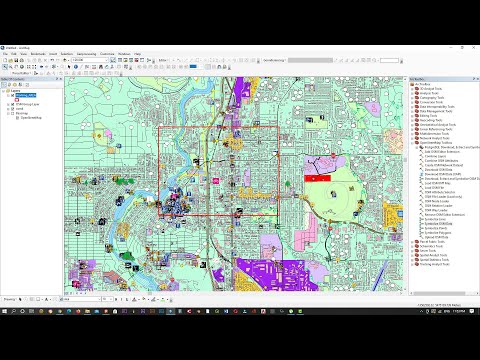
Through this project, we will be mapping and collecting different data from vulnerable households, secondary schools, health centres and communities in streets ODK, monitor field officers using Kobo Tool Box, upload the generated data using JOSM, and lastly, using spatial data (QGIS) to develop evidence-based advocacy to multi-stakeholders.
In our presentation, we will also share how Agri Thamani used OSM tool and how we used the GIS to develop powerful advocacy maps and telling a story of interventions through maps, which enabled us to achieve buy-in from decision makers.
Tanzania has the 3rd highest number of stunted children in Africa, which is unacceptably high and Agri Thamani identified gaps in linking agricultural activities to improve nutrition outcomes in regions with high rates of malnutrition such as Kagera. In efforts of bridging these gaps Agri Thamani needed authentic data to be used in its evidence-based advocacy and this is where the need for data comes in.
Accordingly, Agri Thamani became part of OSM Community through the HOTSM Micro Grant by Open Map Development Tanzania (OMDTZ) under the project known as; “Mapping Nutrition Interventions and the Most Vulnerable Households in Bukoba Municipal”.
Through this project, we will be mapping and collecting different data from vulnerable households, secondary schools, health centres and communities in streets ODK, monitor field officers using Kobo Tool Box, upload the generated data using JOSM, and lastly, using spatial data (QGIS) to develop evidence-based advocacy to multi-stakeholders.
In our presentation, we will also share how Agri Thamani used OSM tool and how we used the GIS to develop powerful advocacy maps and telling a story of interventions through maps, which enabled us to achieve buy-in from decision makers.
 0:07:22
 0:07:08
 0:15:02
 0:02:10
 0:14:20
 0:27:23
 0:05:57
 0:06:23
 1:17:08
 0:07:04
 0:11:39
 0:03:01
 0:11:07
 0:11:00
 0:03:26
 0:10:00
 0:09:13
 0:08:34
 0:09:39
 0:07:39
 0:36:42
 0:02:45
 0:15:40
 0:10:02