filmov
tv
Cleveland weather forecast: Tracking potential impact of Helene

Показать описание
Here's your Cleveland weather forecast from 3News Chief Meteorologist Betsy Kling:
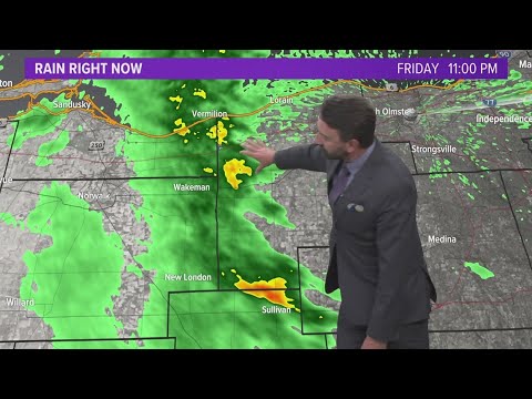
The elephant in the room is what happens with what will be Hurricane Helene. Helene is expected to gain strength today in the Gulf of Mexico and will likely become a major hurricane during the day tomorrow before making landfall in the Big Bend region of Florida to the north of Cedar Key.
The remnants of Helene will then work north and quickly get absorbed into an upper level low in the Tennessee Valley. For us locally, we'll turn rather breezy if not windy around here Friday with increasing clouds and some rain showers moving in later in the day. The breeze should back off quickly on Saturday with lingering showers at times both Saturday and Sunday. Overall impacts look low for us here in Ohio, but we'll have to keep our eye on the gusty wind potential Friday.
Rain chances will stay in the forecast Monday into Tuesday before a sweeping cold front moves through northern Ohio, bringing our first true hit of fall-like air for a few days later next week. Highs will likely be in the 60s with drier, more comfortable air working in.
 0:04:31
Cleveland weather forecast: Tracking potential impact of Helene
 0:07:35
Tracking potentially severe weather in Northeast Ohio with big temperature changes on the way
 0:04:26
Cleveland weather forecast: Helene to impact Northeast Ohio on Friday
 0:04:20
Cleveland Weather: Tracking Tuesday storms
 0:01:39
Cleveland weather: Tracking severe weather in parts of Northeast Ohio
 0:02:59
Tracking rain chances: Extended Cleveland weather forecast for September 23, 2024
 0:03:25
Cleveland weather: Tracking rain and storms ahead of much cooler temperatures in Northeast Ohio
 0:03:17
Cleveland weather forecast: Tracking rain, wind and changing temperatures
 0:15:02
The First Alert 🌀︱Sept. 26, 2024
 0:03:08
Tracking storms and cooler temperatures: Cleveland weather forecast on July 29, 2021
 0:02:57
Cleveland weather forecast: Tracking scattered rain before the heat returns
 0:03:21
Tracking another round of snow: Cleveland weather forecast for January 27, 2023
 0:01:50
Monday's extended Cleveland weather forecast: Tracking several rounds of snow for this week
 0:03:31
Wednesday's Cleveland weather forecast: Tracking scattered rain and storms in Northeast Ohio
 0:02:17
Cleveland weather forecast: Tracking rain and storms ahead of cooler temperatures for May 26, 2021
 0:03:14
Cleveland area weather forecast: All eyes on Hurricane Helene as remnants bring wind, rain
 0:04:00
Cleveland weather forecast | Tracking rainy conditions: What to expect this weekend
 0:02:31
Extended Cleveland weather forecast: Tracking rain chances for several days
 0:04:13
Cleveland Weather: Tracking severe storms: Level 3 risk
 0:04:34
Cleveland area weather forecast: Impacts of Hurricane Helene
 0:02:04
Friday's extended Cleveland weather forecast: Tracking another round of snow for Northeast Ohio
 0:03:22
Tracking severe storms: Cleveland weather forecast with Hollie Strano for June 18, 2021
 0:02:23
Wednesday's extended Cleveland weather forecast: Tracking a quick round of rain / snow for late...
 0:03:14
Tracking accumulating snow in spots: Cleveland weather forecast for November 16, 2022
Комментарии