filmov
tv
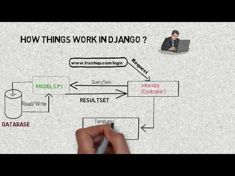
Map plotting with Django and Google's Roads Api

Показать описание
We can plot the GPS coordinates in a map to show a user's path. But sometimes due to noise, these GPS coordinates can end up in different places than the exact path of the road. As a result, we can get a very odd-looking path.
Google's roads API helps us to snap those GPS points to the nearest road.
In this very simple project, I used Google's Roads API to plot some GPS coordinates. I used the python language and the Django framework.
There are two parts of the project on the screen. On the left side, the title is "Raw data results", which shows the plot of just GPS coordinates (without the Roads API). On the right side, you can find the "Snapped to road results". This shows the same GPS coordinates of the "Raw data results" after running them with the Road's API.
It was a demo work for a client in Dubai.
 0:00:55
 0:13:48
 0:01:28
 0:21:58
 0:50:32
 0:08:32
 0:25:50
 0:14:35
 0:20:31
 1:26:05
 0:14:05
 0:26:32
 0:16:42
 0:08:43
 0:03:28
 0:15:03
 0:30:56
 0:33:41
 0:30:38
 0:16:45
 0:28:11
 0:22:51
 0:33:17
 0:01:28