filmov
tv
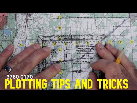
Plotting Points on a Military Topographical Map

Показать описание
Download a free PDF and work alongside me as we plot points on a map and identify grid & magnetic azimuths as well as distance. Utilizing a 1:50 Military Map and a protractor you'll be able to identify features, plan a route, and discover techniques for departing a patrol base and occupying your objective.
Join this channel to get access to perks:
FAVORITE GEAR:
Get up to date on the channel, future content, live, super huge thanks! Check out my Amazon Storefront for great bushcraft, survival, and tactical virtue lists and items, it costs you nothing yet supports the channel:
*Copyright Disclaimer Under Section 107 of the Copyright Act 1976, allowance is made for "fair use" for purposes such as criticism, comment, news reporting, teaching, scholarship, and research. Fair use is a use permitted by copyright statute that might otherwise be infringing. Non-profit, educational or personal use tips the balance in favor of fair use. No copyright infringement intended. ALL RIGHTS BELONG TO THEIR RESPECTIVE OWNERS
*Disclaimers: all opinions are my own. Not financial advice, for entertainment purposes only.
BTW - you're awesome, especially if you've read this much. There's not many like you - Thanks for hanging out with me here for a few minutes.
 0:06:59
How to Plot 8 Digit Grid Coordinates
 0:05:43
SMCT: Determine the Grid Coordinates of a Point on a Military Map
 0:17:50
Plotting Points on a Military Topographical Map
 0:00:56
HOW TO PLOT A POINT ON A MAP
 0:08:38
Land Navigation Demonstration Video
 0:00:27
How to use a protractor to read a military MGRS grid map
 0:04:04
Plotting a Point on a Map - Land Navigation Series (4 digit grid / 6 digit grid)
 0:00:59
Resection / Land Navigation Techniques
 3:27:17
The Sleepless Tale of the Ottoman Empire — From Crescent to Republic
 0:16:23
Master How to Plot 6, 8, and 10 Grid Coordinates on a Topographical Map
 0:01:00
How to plot a point on a map in a minute
 0:03:36
SMCT: Orient a Map Using a Lensatic Compass
 0:09:50
10 Min to Better Land Navigation Part 12 Understanding and Plotting Grid Coordinates
 0:03:06
How to Use Military Protractor for Plotting Bearings ?
 0:02:25
SMCT: Determine Grid Azimuths Using a Protractor
 0:01:34
How to take a compass bearing with Steve Backshall and Ordnance Survey
 0:15:07
Land Navigation Course 3: Plotting Points
 1:06:12
How To Do Land Navigation At Basic Training | Everything You NEED To Know To Pass
 0:00:34
Plotting Targets and Routes with Grid Coordinates
 0:07:36
Plotting UTM Coordinates with a Grid Tool
 0:09:52
Land Navigation with a Lensatic Compass - fast azimuth technique
 0:07:24
SMCT: Convert Azimuths and Compute Back Azimuths
 0:08:50
How to Use a Map and Compass
 0:04:15
How Do GPS Coordinates Work?
Комментарии