filmov
tv
How To Import Study area Shapefile in GEE Asset and make Analysis

Показать описание
Basic To Advance Course On Google Earth Engine
This is a basic to advanced course on google earth engine(GEE). Google Earth Engine is an important Platform for GIS and Remote Sensing analysis. We are focusing these type of people who have no programming skills to run Google earth engine for remote sensing analysis. At the end of this course you will be able to easily manage remote sensing work using Google Earth Engine platform.
Google Earth Engine Course Content:
💥INTRODUCTION:
1 .Introducing About Google Earth Engine
2. How To Create Google Earth Engine Account
3. 3. Introducing Google Earth Engine Code editor
4. Familiarity With the Basic JavaScript Syntex in GEE
5. Introducing Client Vs Server Object in Google Earth Engine
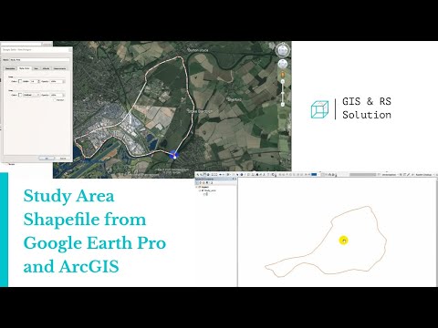
6. Basic of Import and Export Any Raster and Vector data in Google Earth Engine
🎯Calculating Band Combination In GEE:
7. Band Combination Using Satellite Imagery
8. Band Combination of Different Dataset in GEE
📸 Basic Of Image Visualization:
9. How to Filtering Satellite image in GEE
10. How to Displaying Satellite image in GEE
🎗Calculating Indices in GEE:
11. Normalized Difference Vegetation Index (NDVI)
12. Enhanced Vegetation Index (EVI)
13. Normalized Difference Water Index (NDWI)
14. Normalized Difference Buildup Index (NDBI)
15. Normalized Difference Drought Index (NDDI)
16. Normalized Difference Snow Index (NDSI) and others
17. How To make Time series Chart and Data for all indices
🎗Calculating Soil Moisture:
18. Soil Moisture Index in GEE
19. Calculating Average Prof Soil Moisture Index in GEE
🎗Land Surface Temperature Monitoring:
20. How To Calculate Land Surface Temperature(LST) Monitoring using MODIS Dataset in GEE
21. How To Calculate Land Surface Temperature(LST) Monitoring using Landsat Dataset in GEE
22. How to Calculate Land Aerosol Optical Depth(AOD) in GEE
23. How To make Time series Chart and time series Data for LST in GEE
🎗Calculating Air Quality Monitoring Parameter:
24. How To Calculate Carbon Monoxide (CO) unit (mol/m^2) using GEE
25. How To Calculate Nitrogen Dioxide (NO2) unit (mol/m^2) using GEE
26. How To Calculate Sulphur Dioxide (SO2) unit (mol/m^2) using GEE
27. How To Calculate Methane (CH4 using GEE platform
28. How to Make Time series Chart and data for all Air quality parameters in GEE
🎗Calculate Digital Elevation Model (DEM) Data
29. How To make Hill shade ,Slope & Aspect Map using Different Dataset in GEE
30. How To Export Hill shade ,Slope & Aspect Map using Different Dataset in GEE
🎗Land Use Land Cover (LULC) Analysis
31. How To Create LULC Map Using GEE Platform
32. How To Apply supervised & Unsupervised Classification Using GEE
33. How To Apply Random Forest & CART Classifier in GEE
34. Accuracy Assessment of LULC (producer accuracy, Kappa accuracy and others)
35. How To Calculate Area for each LULC Class in Google Earth Engine
Contact information:
Next batch start time: 31th May
Total Class: 8 days (2 days weekly Friday and Saturday )
Class Duration: 3 hours (Each day)
Time: 9:00 P.M to 12:00 A.M (GMT +6)
🛑Join Our Community
Telegram Group
🛑 YouTube Channel
Facebook Group
Facebook Page
Follow Instagram
Linkedin Account
This is a basic to advanced course on google earth engine(GEE). Google Earth Engine is an important Platform for GIS and Remote Sensing analysis. We are focusing these type of people who have no programming skills to run Google earth engine for remote sensing analysis. At the end of this course you will be able to easily manage remote sensing work using Google Earth Engine platform.
Google Earth Engine Course Content:
💥INTRODUCTION:
1 .Introducing About Google Earth Engine
2. How To Create Google Earth Engine Account
3. 3. Introducing Google Earth Engine Code editor
4. Familiarity With the Basic JavaScript Syntex in GEE
5. Introducing Client Vs Server Object in Google Earth Engine
6. Basic of Import and Export Any Raster and Vector data in Google Earth Engine
🎯Calculating Band Combination In GEE:
7. Band Combination Using Satellite Imagery
8. Band Combination of Different Dataset in GEE
📸 Basic Of Image Visualization:
9. How to Filtering Satellite image in GEE
10. How to Displaying Satellite image in GEE
🎗Calculating Indices in GEE:
11. Normalized Difference Vegetation Index (NDVI)
12. Enhanced Vegetation Index (EVI)
13. Normalized Difference Water Index (NDWI)
14. Normalized Difference Buildup Index (NDBI)
15. Normalized Difference Drought Index (NDDI)
16. Normalized Difference Snow Index (NDSI) and others
17. How To make Time series Chart and Data for all indices
🎗Calculating Soil Moisture:
18. Soil Moisture Index in GEE
19. Calculating Average Prof Soil Moisture Index in GEE
🎗Land Surface Temperature Monitoring:
20. How To Calculate Land Surface Temperature(LST) Monitoring using MODIS Dataset in GEE
21. How To Calculate Land Surface Temperature(LST) Monitoring using Landsat Dataset in GEE
22. How to Calculate Land Aerosol Optical Depth(AOD) in GEE
23. How To make Time series Chart and time series Data for LST in GEE
🎗Calculating Air Quality Monitoring Parameter:
24. How To Calculate Carbon Monoxide (CO) unit (mol/m^2) using GEE
25. How To Calculate Nitrogen Dioxide (NO2) unit (mol/m^2) using GEE
26. How To Calculate Sulphur Dioxide (SO2) unit (mol/m^2) using GEE
27. How To Calculate Methane (CH4 using GEE platform
28. How to Make Time series Chart and data for all Air quality parameters in GEE
🎗Calculate Digital Elevation Model (DEM) Data
29. How To make Hill shade ,Slope & Aspect Map using Different Dataset in GEE
30. How To Export Hill shade ,Slope & Aspect Map using Different Dataset in GEE
🎗Land Use Land Cover (LULC) Analysis
31. How To Create LULC Map Using GEE Platform
32. How To Apply supervised & Unsupervised Classification Using GEE
33. How To Apply Random Forest & CART Classifier in GEE
34. Accuracy Assessment of LULC (producer accuracy, Kappa accuracy and others)
35. How To Calculate Area for each LULC Class in Google Earth Engine
Contact information:
Next batch start time: 31th May
Total Class: 8 days (2 days weekly Friday and Saturday )
Class Duration: 3 hours (Each day)
Time: 9:00 P.M to 12:00 A.M (GMT +6)
🛑Join Our Community
Telegram Group
🛑 YouTube Channel
Facebook Group
Facebook Page
Follow Instagram
Linkedin Account
 0:05:32
 0:03:40
 0:11:42
 0:15:32
 0:07:38
 0:14:56
 0:00:15
 0:06:45
 0:02:35
 0:13:51
 0:17:14
 0:35:19
 0:02:59
 0:26:28
 0:07:03
 0:08:56
 0:09:02
 0:03:35
 0:04:13
 0:05:58
 0:01:43
 0:04:30
 0:08:50
 0:06:19