filmov
tv
NCERT Class 11 Geography Practical Chapter 3: Longitude, Latitude, Time | CBSE | English
Показать описание
Dr. Manishika Jain in this video explains NCERT Class 11 Geography Practical Chapter 3: Longitude, Latitude, Time
Map
Map Scale
Atlas map
wall map
Post-Production: Pooja
Data its source and compilation notes
Data its source and compilation NCERT solutions
Data its source and compilation class 11
Data its source and compilation
Geography practical class 11 NCERT solutions
Practical work in geography class 11 solutions
Geography practical book class 11 solutions
NCERT, Yojana, Kurukshetra, Down to Earth, Science, Social Studies and More interesting topics subscribe in Hindi
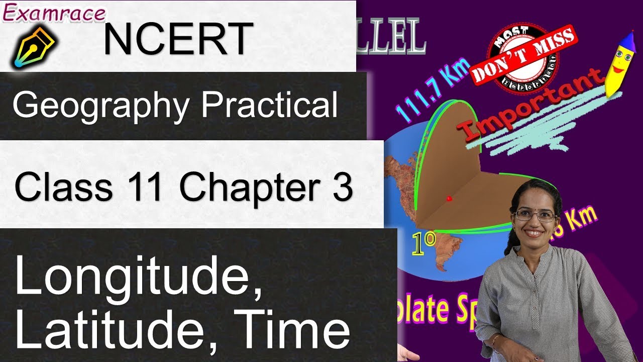
Equatorial radius and the polar radius of the earth is not the same
Rotation on axis produces bulge at equator
network of imaginary lines is drawn on a globe or a map to locate various places – geographical grid
The grid consists of two sets of horizontal and vertical lines, which are called parallels of latitudes and the meridians of longitudes
Horizontal lines parallel to each other and appear as circles
Angular distance, in degrees, minutes and seconds of a point north or south of the Equator
Midway between north & south pole is equator
Divide globe in 2 equal half – great circle
Rest are smaller – called parallels or latitude
If parallels of latitude are drawn at an interval of one degree, there will be 89 parallels in the northern and the southern hemispheres each. The total number of parallels thus drawn, including the equator, will be 179.
If earth was perfect sphere – length of one degree would be 111 km and would be same as longitude.
But the degree of latitude changes slightly in length from the equator to the poles. While at the equator, it is 110.6 km at the poles, it is 111.7 km.
Latitude of a place may be determined with the help of the altitude of the sun or the Pole Star.
Draw Parallels: Draw a circle and divide it into two equal halves by drawing a horizontal line in the centre. This represents the equator. Place a protractor on this circle in a way that 0° and 180° line on the protractor coincide with the equator on the paper. Now to draw 20°S, mark two points at an angle of 20° from the equator, east and west in the lower half of the circle. The arms of the angle cut the circle at two points. Join these two points by a line parallel to the equator. It will be 200S.
Chapters:
0:00 Longitude, Latitude,
0:20 Earth is Oblate Spheroid
0:32 Equatorial Radius
1:04 Geographical Grid
1:37 Latitude or Parallel
3:37 Great Circle
4:36 Different Region
4:47 Longitude or Meridian
7:26 Prime (Greenwich) Meridian
8:11 Solving Problems on Latitude & Longitude
10:56 International Data Line
12:21 Asian Countries – American Continent
#Longitude #Meridian #Torrid #Frigid #Developed #Latitude #Parallel #Radius #Spheroid #Equatorial #Manishika #Examrace #examrace #upsc #ugcnet
Map
Map Scale
Atlas map
wall map
Post-Production: Pooja
Data its source and compilation notes
Data its source and compilation NCERT solutions
Data its source and compilation class 11
Data its source and compilation
Geography practical class 11 NCERT solutions
Practical work in geography class 11 solutions
Geography practical book class 11 solutions
NCERT, Yojana, Kurukshetra, Down to Earth, Science, Social Studies and More interesting topics subscribe in Hindi
Equatorial radius and the polar radius of the earth is not the same
Rotation on axis produces bulge at equator
network of imaginary lines is drawn on a globe or a map to locate various places – geographical grid
The grid consists of two sets of horizontal and vertical lines, which are called parallels of latitudes and the meridians of longitudes
Horizontal lines parallel to each other and appear as circles
Angular distance, in degrees, minutes and seconds of a point north or south of the Equator
Midway between north & south pole is equator
Divide globe in 2 equal half – great circle
Rest are smaller – called parallels or latitude
If parallels of latitude are drawn at an interval of one degree, there will be 89 parallels in the northern and the southern hemispheres each. The total number of parallels thus drawn, including the equator, will be 179.
If earth was perfect sphere – length of one degree would be 111 km and would be same as longitude.
But the degree of latitude changes slightly in length from the equator to the poles. While at the equator, it is 110.6 km at the poles, it is 111.7 km.
Latitude of a place may be determined with the help of the altitude of the sun or the Pole Star.
Draw Parallels: Draw a circle and divide it into two equal halves by drawing a horizontal line in the centre. This represents the equator. Place a protractor on this circle in a way that 0° and 180° line on the protractor coincide with the equator on the paper. Now to draw 20°S, mark two points at an angle of 20° from the equator, east and west in the lower half of the circle. The arms of the angle cut the circle at two points. Join these two points by a line parallel to the equator. It will be 200S.
Chapters:
0:00 Longitude, Latitude,
0:20 Earth is Oblate Spheroid
0:32 Equatorial Radius
1:04 Geographical Grid
1:37 Latitude or Parallel
3:37 Great Circle
4:36 Different Region
4:47 Longitude or Meridian
7:26 Prime (Greenwich) Meridian
8:11 Solving Problems on Latitude & Longitude
10:56 International Data Line
12:21 Asian Countries – American Continent
#Longitude #Meridian #Torrid #Frigid #Developed #Latitude #Parallel #Radius #Spheroid #Equatorial #Manishika #Examrace #examrace #upsc #ugcnet
 0:22:17
NCERT Class 11 Geography Practical Chapter 1: Introduction to Maps | CBSE | English
 0:36:21
NCERT Class 11 Practical Geography Chapter 4: Map Projections | CBSE | English
 0:14:13
NCERT Class 11 Geography Practical Chapter 3: Longitude, Latitude, Time | CBSE | English
 0:16:47
NCERT Class 11 Geography Practical Chapter 2: Map Scale - Construction | English
 0:26:35
NCERT Class 11 Practical Geography Chapter 6: Introduction to Aerial Photographs
 0:00:19
A satisfying chemical reaction
 0:23:58
Introduction to Maps-Chapter 1 -NCERT Class 11 -TheGeoecologist
 0:27:00
NCERT Class 11 Practical Geography Chapter 5: Topographical Maps | CBSE | English |Plotting Contours
 0:29:35
NCERT Class 11 Practical Geography Chapter 7: Introduction to Remote Sensing | CBSE | English
 0:35:41
MAP SCALE | CH-2 | CLASS-11 | PRACTICAL WORK IN GEOGRAPHY (PART 1) | NCERT
 0:00:31
Hydrophobic Club Moss Spores
 0:00:30
Carbon Laser Peel treatment at Skinaa Clinic | Viral #shorts
 0:06:39
India location | Class 11 Geography Chapter 1 in one shot Animation | AakashY9
 0:00:26
Next Level Pen 🖊
 0:02:50
Geography Practical File (Part II) #class11 #humanities #geography #SchoolingGuide
 0:00:35
Geography Practical Class11 (from NCERT Syllabus)
 0:03:23
Class 11 NCERT Practicals Chapter 2 | Dividing a line Method 1
 0:00:16
BIOLOGY PRACTICALS 🪳🔬🦠🧪 #biology #experiment #like #practical #science #share #subscribe
 0:04:20
Aerial photo Interpretation #Ncert#class11#Geography practical.
 0:00:16
Reproduction Ka practical 😅😂 Funniest moments during Online class #alakhpandey #physicswallah
 0:14:38
How to Read NCERT Geography For UPSC | Only 1% Aspirants Know This Strategy | 6 to 12 NCERT
 0:32:33
India Location | One Shot Video | Class 11 Geography | NCERT Chapter 1 | Padhle
 0:16:25
NCERT Class 11 Practical Geography Chapter 8: Weather Instruments, Maps and Charts
 0:00:28
From 74% in 12th to 621 in NEET🔥#shorts #neet
Комментарии