filmov
tv
Plotting World Map Using Pygal in Python

Показать описание
Plotting World Map Using Pygal in Python
The code is given in the comment box or description
Pygal is a Python module that is mainly used to build SVG (Scalar Vector Graphics) graphs and charts. SVG is a vector-based graphics in the XML format that can be edited in any editor. Pygal can create graphs with minimal lines of code that can be easy to understand and write.
We might want to plot the World Map with country wise boundaries and might even want to represent or differentiate countries on a geographical basis or based on some data in our project. Python Library “Pygal” will help us achieve our task. So let’s get started.
Installation
pip install pygal_maps_world
Syntax:
Now you can plot the graph of the countries by using their country code. Here is the list of the country code.
Codes Countries
ad Andorra
ae United Arab Emirates
af Afghanistan
al Albania
am Armenia
ao Angola
aq Antarctica
ar Argentina
at Austria
au Australia
az Azerbaijan
ba Bosnia and Herzegovina
bd Bangladesh
be Belgium
bf Burkina Faso
bg Bulgaria
bh Bahrain
bi Burundi
bj Benin
bn Brunei Darussalam
bo Bolivia, Plurinational State of
br Brazil
bt Bhutan
bw Botswana
by Belarus
bz Belize
ca Canada
cd Congo, the Democratic Republic of the
cf Central African Republic
cg Congo
ch Switzerland
ci Cote d’Ivoire
cl Chile
cm Cameroon
cn China
co Colombia
cr Costa Rica
cu Cuba
cv Cape Verde
cy Cyprus
cz Czech Republic
de Germany
dj Djibouti
dk Denmark
do Dominican Republic
dz Algeria
ec Ecuador
ee Estonia
eg Egypt
eh Western Sahara
er Eritrea
es Spain
et Ethiopia
fi Finland
fr France
ga Gabon
gb United Kingdom
ge Georgia
gf French Guiana
gh Ghana
gl Greenland
gm Gambia
gn Guinea
gq Equatorial Guinea
gr Greece
gt Guatemala
gu Guam
gw Guinea-Bissau
gy Guyana
hk Hong Kong
hn Honduras
hr Croatia
ht Haiti
hu Hungary
id Indonesia
ie Ireland
il Israel
in India
iq Iraq
ir Iran, Islamic Republic of
is Iceland
it Italy
jm Jamaica
jo Jordan
jp Japan
ke Kenya
kg Kyrgyzstan
kh Cambodia
kp Korea, Democratic People’s Republic of
kr Korea, Republic of
kw Kuwait
kz Kazakhstan
la Lao People’s Democratic Republic
lb Lebanon
li Liechtenstein
lk Sri Lanka
lr Liberia
ls Lesotho
lt Lithuania
lu Luxembourg
lv Latvia
ly Libyan Arab Jamahiriya
ma Morocco
mc Monaco
md Moldova, Republic of
me Montenegro
mg Madagascar
mk Macedonia, the former Yugoslav Republic of
ml Mali
mm Myanmar
mn Mongolia
mo Macao
mr Mauritania
mt Malta
mu Mauritius
mv Maldives
mw Malawi
mx Mexico
my Malaysia
mz Mozambique
na Namibia
ne Niger
ng Nigeria
ni Nicaragua
nl Netherlands
no Norway
np Nepal
nz New Zealand
om Oman
pa Panama
pe Peru
pg Papua New Guinea
ph Philippines
pk Pakistan
pl Poland
pr Puerto Rico
ps Palestine, State of
pt Portugal
py Paraguay
re Reunion
ro Romania
rs Serbia
ru Russian Federation
rw Rwanda
sa Saudi Arabia
sc Seychelles
sd Sudan
se Sweden
sg Singapore
sh Saint Helena, Ascension and Tristan da Cunha
si Slovenia
sk Slovakia
sl Sierra Leone
sm San Marino
sn Senegal
so Somalia
sr Suriname
st Sao Tome and Principe
sv El Salvador
sy Syrian Arab Republic
sz Swaziland
td Chad
tg Togo
th Thailand
tj Tajikistan
tl Timor-Leste
tm Turkmenistan
tn Tunisia
tr Turkey
tw Taiwan (Republic of China)
tz Tanzania, United Republic of
ua Ukraine
ug Uganda
us United States
uy Uruguay
uz Uzbekistan
va Holy See (Vatican City State)
ve Venezuela, Bolivarian Republic of
vn Viet Nam
ye Yemen
yt Mayotte
za South Africa
zm Zambia
zw Zimbabwe
Example 1: Plotting Countries Based on Data.
Link 🔗:#3
print("Success")
Output:
countries plot
Example 2: Plotting Countries with labels.
Link 🔗:#2
Output
countries plot
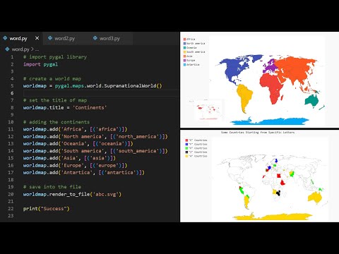
Example 3: Plotting Continents.
Link 🔗:#1
Output:
Tags : Python,
Data Visualization,
Python-pygal,
Python turtle graphics code examples,
Turtle graphics Python,
Python turtle graphics download,
Awesome Python turtle codes PDF,
1000 Python programs PDF,
Python Programs for Interview,
Python programs for practice pdf,
#Like #share #& #subscribe
##softwareengineer #ballpythons #pythoncode #mrprogrammer #software #reptilesofinstagram #webdevelopment #webdeveloper #tech #codinglife
Mr. Programmer
The program is given in the comment box
Programmers write code for computer programs and mobile applications. They also are involved in maintaining, debugging and troubleshooting systems and software to ensure that everything is running smoothly.
Mr. Programmer writes code in all programming languages. If you have any questions about any programming language, you can write questions in the comment box. Of course you do The program or video of that program will be provided.
#mybtstory
#MrProgrammer
The code is given in the comment box or description
Pygal is a Python module that is mainly used to build SVG (Scalar Vector Graphics) graphs and charts. SVG is a vector-based graphics in the XML format that can be edited in any editor. Pygal can create graphs with minimal lines of code that can be easy to understand and write.
We might want to plot the World Map with country wise boundaries and might even want to represent or differentiate countries on a geographical basis or based on some data in our project. Python Library “Pygal” will help us achieve our task. So let’s get started.
Installation
pip install pygal_maps_world
Syntax:
Now you can plot the graph of the countries by using their country code. Here is the list of the country code.
Codes Countries
ad Andorra
ae United Arab Emirates
af Afghanistan
al Albania
am Armenia
ao Angola
aq Antarctica
ar Argentina
at Austria
au Australia
az Azerbaijan
ba Bosnia and Herzegovina
bd Bangladesh
be Belgium
bf Burkina Faso
bg Bulgaria
bh Bahrain
bi Burundi
bj Benin
bn Brunei Darussalam
bo Bolivia, Plurinational State of
br Brazil
bt Bhutan
bw Botswana
by Belarus
bz Belize
ca Canada
cd Congo, the Democratic Republic of the
cf Central African Republic
cg Congo
ch Switzerland
ci Cote d’Ivoire
cl Chile
cm Cameroon
cn China
co Colombia
cr Costa Rica
cu Cuba
cv Cape Verde
cy Cyprus
cz Czech Republic
de Germany
dj Djibouti
dk Denmark
do Dominican Republic
dz Algeria
ec Ecuador
ee Estonia
eg Egypt
eh Western Sahara
er Eritrea
es Spain
et Ethiopia
fi Finland
fr France
ga Gabon
gb United Kingdom
ge Georgia
gf French Guiana
gh Ghana
gl Greenland
gm Gambia
gn Guinea
gq Equatorial Guinea
gr Greece
gt Guatemala
gu Guam
gw Guinea-Bissau
gy Guyana
hk Hong Kong
hn Honduras
hr Croatia
ht Haiti
hu Hungary
id Indonesia
ie Ireland
il Israel
in India
iq Iraq
ir Iran, Islamic Republic of
is Iceland
it Italy
jm Jamaica
jo Jordan
jp Japan
ke Kenya
kg Kyrgyzstan
kh Cambodia
kp Korea, Democratic People’s Republic of
kr Korea, Republic of
kw Kuwait
kz Kazakhstan
la Lao People’s Democratic Republic
lb Lebanon
li Liechtenstein
lk Sri Lanka
lr Liberia
ls Lesotho
lt Lithuania
lu Luxembourg
lv Latvia
ly Libyan Arab Jamahiriya
ma Morocco
mc Monaco
md Moldova, Republic of
me Montenegro
mg Madagascar
mk Macedonia, the former Yugoslav Republic of
ml Mali
mm Myanmar
mn Mongolia
mo Macao
mr Mauritania
mt Malta
mu Mauritius
mv Maldives
mw Malawi
mx Mexico
my Malaysia
mz Mozambique
na Namibia
ne Niger
ng Nigeria
ni Nicaragua
nl Netherlands
no Norway
np Nepal
nz New Zealand
om Oman
pa Panama
pe Peru
pg Papua New Guinea
ph Philippines
pk Pakistan
pl Poland
pr Puerto Rico
ps Palestine, State of
pt Portugal
py Paraguay
re Reunion
ro Romania
rs Serbia
ru Russian Federation
rw Rwanda
sa Saudi Arabia
sc Seychelles
sd Sudan
se Sweden
sg Singapore
sh Saint Helena, Ascension and Tristan da Cunha
si Slovenia
sk Slovakia
sl Sierra Leone
sm San Marino
sn Senegal
so Somalia
sr Suriname
st Sao Tome and Principe
sv El Salvador
sy Syrian Arab Republic
sz Swaziland
td Chad
tg Togo
th Thailand
tj Tajikistan
tl Timor-Leste
tm Turkmenistan
tn Tunisia
tr Turkey
tw Taiwan (Republic of China)
tz Tanzania, United Republic of
ua Ukraine
ug Uganda
us United States
uy Uruguay
uz Uzbekistan
va Holy See (Vatican City State)
ve Venezuela, Bolivarian Republic of
vn Viet Nam
ye Yemen
yt Mayotte
za South Africa
zm Zambia
zw Zimbabwe
Example 1: Plotting Countries Based on Data.
Link 🔗:#3
print("Success")
Output:
countries plot
Example 2: Plotting Countries with labels.
Link 🔗:#2
Output
countries plot
Example 3: Plotting Continents.
Link 🔗:#1
Output:
Tags : Python,
Data Visualization,
Python-pygal,
Python turtle graphics code examples,
Turtle graphics Python,
Python turtle graphics download,
Awesome Python turtle codes PDF,
1000 Python programs PDF,
Python Programs for Interview,
Python programs for practice pdf,
#Like #share #& #subscribe
##softwareengineer #ballpythons #pythoncode #mrprogrammer #software #reptilesofinstagram #webdevelopment #webdeveloper #tech #codinglife
Mr. Programmer
The program is given in the comment box
Programmers write code for computer programs and mobile applications. They also are involved in maintaining, debugging and troubleshooting systems and software to ensure that everything is running smoothly.
Mr. Programmer writes code in all programming languages. If you have any questions about any programming language, you can write questions in the comment box. Of course you do The program or video of that program will be provided.
#mybtstory
#MrProgrammer
 0:01:00
Plotting World Map Using Pygal in Python
 0:00:26
Plotting World Map Using Pygal in Python #short #shorts
 0:08:17
World map with PyGal in Python in SVG format
 0:02:43
World Map With Python and Pygal
 0:03:43
How to plot geographic location in Python | Choropleth map
 0:18:17
Creating Geographic Maps with plotly express
 0:00:15
Plotting world map using Python -part 2#codeing #machinelearning #pythonprogramming
 0:00:21
BROWSER USAGE EVOLUTION GRAPH USING PYTHON PYGAL
 0:28:15
Data Visualization with PyGal -- Pymntos Meetup
 0:15:13
Data Visualization Using Pygal
 0:14:42
Plotting Geographical MAPS using Python - Plotly [English]
 0:00:57
How to show world map using python folium package.
 0:01:02
Pygal Skills: Build Your First Data Visualization with Pygal Course Preview
 0:00:33
Create World Map using Python #shorts #python #tech
 0:11:32
Python Pygal: Creating Interactive Plots and SVGs
 0:00:36
Quick make a map on python | #matplotlib #coding #map #python @learneverythingonline4u 🫠🫠🌎🌎🌎🌎🌏🌏📍📍...
 0:07:27
Introduction and Installation of the Pygal python visualization library
 0:26:45
Mapping the World in Python: How to do it with Cartopy, XArray, and NetCDF Data
 0:48:41
Carona Cases Data Visualization using Pygal library
 0:18:51
Visualization of world map : in just 10 line of code in python
 0:11:04
💡Mapping Global Data Sets with Python: Tutorial for Beginners
 0:26:50
Create a scatterplot graph using Pygal Library and Pandas in Python.
 0:04:47
PLOT CORONA CASES ON WORLD-MAP | TABLEAU | 5 MINUTES
 0:07:55
How to plot coordinates on a map with geopandas python , matplotlib
Комментарии