filmov
tv
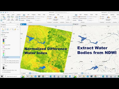
Generating NDWI and Extracting Water Bodies with Landsat 8 in ArcGIS Pro

Показать описание
🌊 Dive into the world of remote sensing with our step-by-step tutorial on generating NDWI (Normalized Difference Water Index) and extracting water bodies using Landsat 8 imagery in ArcGIS Pro! 🛰️
In this tutorial, we'll guide you through the process of harnessing the power of Landsat 8 satellite data to identify and map water bodies with precision. Learn how to enhance your environmental analysis by calculating NDWI, a key index for water detection, and utilize the advanced tools in ArcGIS Pro for accurate water body extraction.
🔍 What You'll Learn:
1️⃣ Introduction to NDWI and its significance in remote sensing.
2️⃣ Accessing Landsat 8 imagery in ArcGIS Pro.
3️⃣ Pre-processing steps for optimal data analysis.
4️⃣ Calculating NDWI to highlight water features.
5️⃣ Techniques for visualizing and interpreting NDWI results.
6️⃣ Utilizing image classification tools for water body extraction.
7️⃣ Fine-tuning your results for precise mapping.
-----------------------------------------------------------------
🔗 Resources Mentioned:
-----------------------------------------------------------------
Whether you're a GIS enthusiast, environmental scientist, or simply curious about leveraging satellite data, this tutorial will empower you to unlock valuable insights from Landsat 8 imagery.
-----------------------------------------------------------------
💰🤝🏻Join Membership to get access to perks & Support us🤝🏻💰
-----------------------------------------------------------------
🚀 Get ready to elevate your GIS skills and gain a deeper understanding of water body extraction techniques! Don't forget to like, subscribe, and hit the notification bell to stay updated on our latest tutorials. Let's make mapping water bodies in ArcGIS Pro a breeze! 💧🗺️
-----------------------------------------------------------------
👩💻 Join the Terra Spatial Community:
Engage with fellow learners, share your experiences, and get support on our dedicated community forum.
🌐 Stay connected:
---------------------------------------------------------------
👍 **Don't forget to Like, Share, and Subscribe for more insightful tutorials! 🌐✨
#NDWI #waterbodies #arcgispro #landsat8 #GIS #remotesensing #WaterBodyExtraction #imageprocessing
 0:13:33
Generating NDWI and Extracting Water Bodies with Landsat 8 in ArcGIS Pro
 0:11:45
How to Prepare Normalized Difference Water Index (NDWI) and Extract Water Bodies from NDWI
 0:03:57
Water Body Extraction (NDWI) in QGIS
 0:03:22
NDWI | How to calculate Normalize Difference Water Index in ArcGIS
 0:10:02
EXTRACT WATERBODIES USING NDWI IN GOOGLE EARTH ENGINE #googleearthengine #NDWI #geomaticsengineering
 0:14:42
Extraction of Surface Water using NDWI
 0:04:18
How to calculate NDWI in Arc map | How to Extract Waterbodies from Sentinel 2.
 0:19:38
Creating spectral indices NDVI NDBI NDWI NDMI in ArcGIS pro and water body extraction technique
 0:04:55
Water Body Extraction Using NDWI in ArcGIS with Landsat 8 OLI TIRS Imagery
 0:06:14
How to generate NDWI map ? Normalized Difference Water Index map using ArcGIS || Water Index mapping
 0:11:58
How to extract water body from satellite images using ArcGIS
 0:06:01
NDWI in ArcGIS || How to Create Normalize Difference Water Index in ArcGIS || Waterbody Index Map
 0:12:33
How to extract water body or river shape from landsat 8 image
 0:06:31
How to create Normalized Difference Water Index (NDWI) in Arc GIS
 0:01:00
Using the Normalized Difference Water Index (NDWI) within a Geographic Information Sy... | RTCL.TV
 0:42:17
NDWI(Extraction of Water bodies from satellite imagery)
 0:05:51
NDWI (Normalized Difference Water Index) using Landsat data in Arc GIS
 0:11:41
Calculating Water indices using ENVI and Landsat 8 Images (NDVI, NDWI, WRI, AWEI)
 0:13:31
How to calculate Moisture Index, NDVI , NDWI , using MODIS, Sentinel and Landsat using Senitnel Hub
 0:14:06
How to Calculate NDWI using QGIS | Extract Waterbodies from Satellite Imageries
 0:06:03
Calculating NDWI unsing ENVI Sotware
 0:14:21
Water Indices (NDWI, MNDWI, WRI and AWEI) extraction in ArcGIS
 0:09:47
How to extract water shape river from landsat 8 OLI using ArcGIS
 0:18:09
NDWI vs MNDWI in ArcGIS
Комментарии