filmov
tv
Python GIS - Open, Display and Plot Shapefiles with Geopandas in Google Colab

Показать описание
Python GIS - Open, Display and Plot Shapefiles with Geopandas in Google Colab
Welcome to our comprehensive tutorial on how to import an ESRI Shapefile in Google Colab using the powerful GeoPandas library. If you're looking to work with spatial data and perform geospatial analysis seamlessly in the cloud, this video is a must-watch!
In this tutorial, we'll walk you through the entire process, from installing the necessary library to plotting the Shapefile on a map. Whether you're a GIS enthusiast, a data scientist, or just someone curious about spatial data visualization, this tutorial will equip you with the knowledge you need to get started.
Introduction to GeoPandas and its Importance:
Firstly, we'll provide an overview of the GeoPandas library, which is an essential Python tool for working with geospatial data. GeoPandas extends the capabilities of Pandas to handle geographic data effortlessly, allowing you to read, write, and manipulate spatial data efficiently.
Library Installation:
Before diving into the actual process, we'll guide you through the process of installing GeoPandas in your Google Colab environment. This straightforward setup ensures you have all the necessary tools to work with Shapefiles seamlessly.
Adding Shapefiles to Google Colab:
Next, we'll show you two methods of adding your Shapefiles to the Google Colab environment. You can either upload the files as temporary session storage, which is ideal for quick analysis, or upload them to your Google Drive, providing a more permanent and organized solution for your spatial data.
Reading the Shapefile with GeoPandas:
Once your Shapefile is successfully added to the Colab environment, we'll use GeoPandas to read the data into a DataFrame. GeoPandas makes it incredibly easy to access the geometry and attributes of the Shapefile, simplifying the entire data handling process.
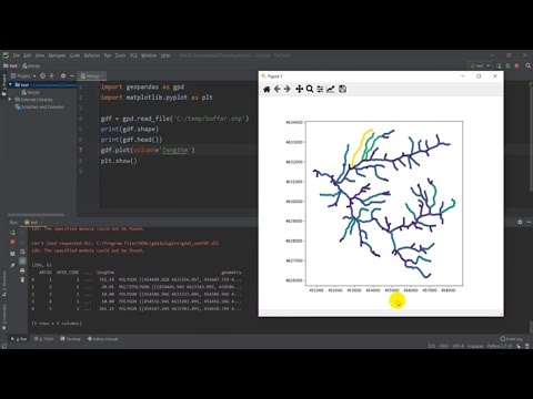
Plotting the Shapefile:
Now comes the exciting part! We'll demonstrate how to use GeoPandas' built-in functions to visualize the Shapefile on an interactive map directly within the Colab notebook. You'll see your spatial data come to life, allowing you to gain valuable insights into the geographic distribution of your information.
Conclusion and Next Steps:
To wrap up the tutorial, we'll provide a quick summary of the steps covered, reinforcing the key concepts you've learned. Additionally, we'll offer some useful tips and resources for further exploration of GeoPandas and geospatial data analysis.
By the end of this tutorial, you'll have a solid foundation in importing ESRI Shapefiles into Google Colab using GeoPandas. This skill set opens up a world of possibilities for data exploration, analysis, and visualization in the geospatial domain.
Whether you're a student, a professional, or an enthusiast, understanding how to work with spatial data in a cloud-based environment like Google Colab is a valuable asset in today's data-driven world. So, hit that play button and let's dive into the exciting world of geospatial analysis with GeoPandas! Don't forget to like, subscribe, and share this tutorial with others who might find it valuable. Happy mapping! 🗺️🌍
Keywords:
Import a Shapefile in Google Colab ,geopandas plot shapefile ,geopandas shapefile , Python GIS,
Display and Plot Shapefiles with Geopandas in Google Colab , python plot shapefile , python display shapefile , geopandas google colab , geopandas , open shapefile with geopandas , geopandas display , geopandas tutorial , import geopandas , geopandas in colab , geopandas colab , python geopandas , python colab tutorial , geopandas read shapefile , geopandas shapefile plot , python gis in hindi , geopandas in google colab , how to install geopandas in google colab ,
#GeoPandas #GoogleColab #ESRIShapefile #GeospatialAnalysis #DataVisualization #Python #GIS
Welcome to our comprehensive tutorial on how to import an ESRI Shapefile in Google Colab using the powerful GeoPandas library. If you're looking to work with spatial data and perform geospatial analysis seamlessly in the cloud, this video is a must-watch!
In this tutorial, we'll walk you through the entire process, from installing the necessary library to plotting the Shapefile on a map. Whether you're a GIS enthusiast, a data scientist, or just someone curious about spatial data visualization, this tutorial will equip you with the knowledge you need to get started.
Introduction to GeoPandas and its Importance:
Firstly, we'll provide an overview of the GeoPandas library, which is an essential Python tool for working with geospatial data. GeoPandas extends the capabilities of Pandas to handle geographic data effortlessly, allowing you to read, write, and manipulate spatial data efficiently.
Library Installation:
Before diving into the actual process, we'll guide you through the process of installing GeoPandas in your Google Colab environment. This straightforward setup ensures you have all the necessary tools to work with Shapefiles seamlessly.
Adding Shapefiles to Google Colab:
Next, we'll show you two methods of adding your Shapefiles to the Google Colab environment. You can either upload the files as temporary session storage, which is ideal for quick analysis, or upload them to your Google Drive, providing a more permanent and organized solution for your spatial data.
Reading the Shapefile with GeoPandas:
Once your Shapefile is successfully added to the Colab environment, we'll use GeoPandas to read the data into a DataFrame. GeoPandas makes it incredibly easy to access the geometry and attributes of the Shapefile, simplifying the entire data handling process.
Plotting the Shapefile:
Now comes the exciting part! We'll demonstrate how to use GeoPandas' built-in functions to visualize the Shapefile on an interactive map directly within the Colab notebook. You'll see your spatial data come to life, allowing you to gain valuable insights into the geographic distribution of your information.
Conclusion and Next Steps:
To wrap up the tutorial, we'll provide a quick summary of the steps covered, reinforcing the key concepts you've learned. Additionally, we'll offer some useful tips and resources for further exploration of GeoPandas and geospatial data analysis.
By the end of this tutorial, you'll have a solid foundation in importing ESRI Shapefiles into Google Colab using GeoPandas. This skill set opens up a world of possibilities for data exploration, analysis, and visualization in the geospatial domain.
Whether you're a student, a professional, or an enthusiast, understanding how to work with spatial data in a cloud-based environment like Google Colab is a valuable asset in today's data-driven world. So, hit that play button and let's dive into the exciting world of geospatial analysis with GeoPandas! Don't forget to like, subscribe, and share this tutorial with others who might find it valuable. Happy mapping! 🗺️🌍
Keywords:
Import a Shapefile in Google Colab ,geopandas plot shapefile ,geopandas shapefile , Python GIS,
Display and Plot Shapefiles with Geopandas in Google Colab , python plot shapefile , python display shapefile , geopandas google colab , geopandas , open shapefile with geopandas , geopandas display , geopandas tutorial , import geopandas , geopandas in colab , geopandas colab , python geopandas , python colab tutorial , geopandas read shapefile , geopandas shapefile plot , python gis in hindi , geopandas in google colab , how to install geopandas in google colab ,
#GeoPandas #GoogleColab #ESRIShapefile #GeospatialAnalysis #DataVisualization #Python #GIS
 0:12:43
Python GIS - Open, Display and Plot Shapefiles with Geopandas in Google Colab
 0:05:58
Python GIS - Open and Display a Shapefile with Geopandas
 0:13:17
Python GIS - Open raster and get information (GDAL)
 0:25:01
Introduction to GIS Analysis with GeoPandas using Python
 0:10:38
Using Python - Open Source GIS
 0:40:39
Anders Lehmann - How to GIS with Python
 1:09:34
GeoSpatial Analysis With Python For Beginners || Use Python For GIS Analysis || The GIS Hub
 0:48:42
An Absolute Beginner's Guide to Python GeoPandas
 0:49:22
Google Earth Engine with Python API for Machine Learning and Deep learning
 0:10:25
GIS and Python: Top Courses to Learn Geospatial Python
 0:10:58
How to Make Interactive Maps with Python - Scatter Mapbox Example with Plotly and OpenStreetMap
 0:07:25
Python GIS - Show a Basemap and Shapfile with Geopandas and Contextily
 0:59:21
ArcGIS API for Python: Introduction to Scripting Your Web GIS
 0:03:35
Three Minutes to Your First Python Script
 0:53:22
Python Programming for GIS Data Processing in QGIS - Functions
 0:27:02
Map it with Python! Intro to GIS and Python mapping modules.
 0:00:25
what it’s like to work at GOOGLE…
 0:22:47
Walkthrough: Mapping GIS Data in Python | Nicole Janeway Bills
 0:05:51
Python Programming for GIS Data Processing in QGIS - Getting Started Setting up working environment
 0:04:05
Python is Your Friend In GIS! Know How to Get Field Data Into a Python List | Python & ArcGIS Pr...
 1:00:22
Full Course - Python for Geospatial Data Analysis for Beginners
 0:14:40
Python GIS - Change Raster Values (GDAL)
 0:17:14
Python GIS - Raster No Data Values (GDAL)
 0:01:00
5 tips on how to get a #GIS #Job #mapping #employment #geospatial #python #data
Комментарии