filmov
tv
How to Use the VFR sectional to pick SAFE Altitudes. (Private Pilot Ground Lesson 26)

Показать описание
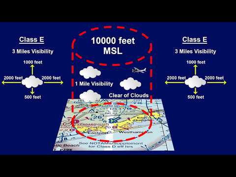
Use your VFR sectional to pick safe altitudes for flight. This free private Pilot ground lesson will help you learn the meanings of all the symbols on VFR sectionals and will give you a place to look for information if you can’t decipher some of the symbols. Specifically, this lesson discusses obstacle symbols on the VFR sectional charts and all the information you might need to know about obstructions, maximum elevation figures, and other obstacle information from the sectional. I also explain how high you can fly above the ground in congested, other than congested, and sparsely populated areas. This information comes from FAR 91.119. This is all information that you will need to know to become a pilot. This information will help you study for the Private Pilot written exam and the oral exam for your check ride. This training is intended to follow the aeronautical knowledge areas in Part 61.105 section b for single engine aircraft.
Get 15% off a great starter headset from Kore Aviation with coupon code: freefreepilottraining
(Help the channel by using the affiliate link below!)
VFR Sectional Users Guide:
WATCH THE WHOLE SERIES HERE!
Free Digital version of the Pilots Handbook of Aeronautical Knowledge:
Airplane Flying Handbook
The links below are affiliate links which allows “Free Pilot Training” to receive a small payment from Amazon any time you use the link below to sign up for programs or purchase items on Amazon. Please consider supporting this channel so we can focus on bringing you more high quality FREE training!
Paper back copy of the Pilot Handbook of Aeronautical Knowledge
Paperback copy of the Airplane Flying Handbook
Please consider supporting us without spending any money!
Try Amazon Prime for FREE for 30 days!
 0:19:49
How I Use ForeFlight as a VFR Private Pilot | Part 1
 0:09:23
How To Use VFR Flight Following
 0:05:44
How to Use the VFR sectional to pick SAFE Altitudes. (Private Pilot Ground Lesson 26)
 0:06:07
VFR Navigational Symbols Explained (Private Pilot Ground Lesson 27)
 0:07:16
VFR Sectional Explained! (All About Airports) Private Pilot Ground Lesson 25
 0:11:38
Ep. 34: How to read a VFR Sectional Chart | Basic Chart/Map Knowledge
 0:15:49
How To Read a VFR Sectional Chart
 0:09:46
FAA Minimum Equipment Required for VFR Flight
 2:54:26
PWDT Yak-18T | VFR Flight in Germany with Logbook and Little NavMap | VATSIM
 0:11:44
ATC's Best Kept Secret: VFR Flight Following
 0:00:53
How to put a VFR 800 VTEC on the center stand
 0:11:03
The Secret To VFR Radio Communications
 0:09:41
FOREFLIGHT VFR SETTINGS GUIDE!
 0:06:37
Can you land here VFR?
 0:26:12
VATSIM UK VFR Pilot Tutorials: Getting started and first circuit
 0:15:29
How to Get Flight Following | Flight Following Explained
 0:51:57
VFR Flight Planning Using ForeFlight
 0:20:26
VFR Flight Planning
 0:17:58
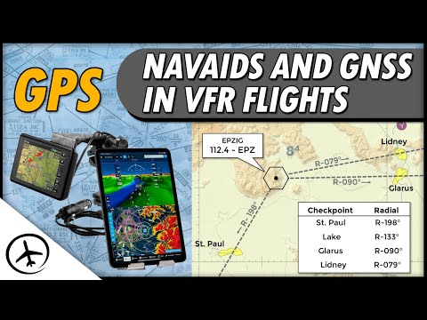
Use of Navaids and GNSS in VFR Navigation
 0:19:18
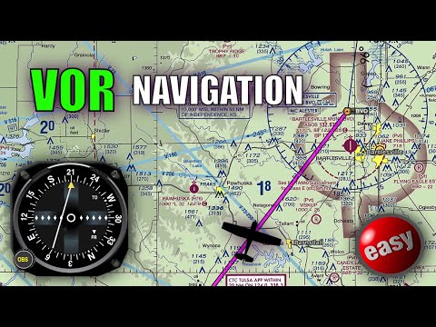
You WILL Understand VORs after Watching This! (PPL Lesson 37)
 0:04:46
Special VFR
 0:05:29
How to Use VOR Navigation on Flight Simulator + Pilotage for VFR Flight and How to Create a Nav Log
 0:09:01
All about IFR / VFR (atc for you)
 0:12:29
How To Read A VFR Sectional Chart - MzeroA Flight Training
Комментарии