filmov
tv
Taupo Supervolcano Update; A Magnitude 5.4 Earthquake Strikes the Volcano

Показать описание
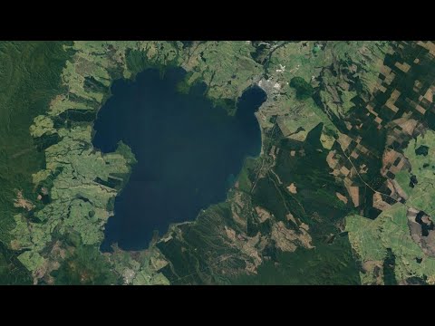
In New Zealand, the supervolcano known as Lake Taupo to the south of the city of Taupo produced an unusually large earthquake which registered in as a magnitude 5.4. This occurred while the volcano was at a raised alert level, and caused cracks to appear in areas surrounding the lake. Despite potentially having a volcanic origin, this quake is not as worrying as you might think it is.
Thumbnail Photo Credit: NASA Worldview, EOSDIS Worldview, Terra / Modis. Satellite image taken on October 8th, 2022.
NASA EOSDIS Worldview satellite imagery Copyright © 2012-2022 United States Government
as represented by the Administrator of the
National Aeronautics and Space Administration.
All Rights Reserved.
We acknowledge the use of imagery provided by services from NASA's Global Imagery Browse Services (GIBS), part of NASA's Earth Observing System Data and Information System (EOSDIS).
Note: Usage of NASA imagery does NOT convey an endorsement of this youtube channel, GeologyHub, or any advertisements shown at the beginning, during the video, or at the end of this video.
Become a channel member to get access to perks:
Google Earth imagery used in this video: ©Google & Data Providers
Creative Commons Licenses used for specific content (such as a single image within the video which as a whole does not entirely fall under the same license) or sections of specific content (such as a photo within a table) in this video (not the entire table for this example):
Sources/Citations:
0:00 M5.4 Earthquake
1:16 Geologic Setting
1:50 VT Earthquakes
2:53 Aftershocks
3:04 Conclusion
 0:03:15
Taupo Supervolcano Update; A Magnitude 5.4 Earthquake Strikes the Volcano
 0:04:42
Taupo Supervolcano Update; Alert Level Raised for the First Time, Earthquake Swarm
 0:04:20
Taupo Supervolcano Update; Ongoing Earthquake Swarm, Seismic Unrest
 0:05:04
Taupō supervolcano and caldera – Ōruanui eruption, 25,500 years ago
 0:04:40
The Largest Volcanic Eruption to Ever Occur; The VEI 9 Toba Eruption
 0:01:38
Volcano Eruptions Size Comparison (2021)
 0:06:25
New Zealand's Super Volcano - Lake Taupo - Part 1
 0:08:20
Biggest Volcano Eruption Comparison On The Earth 🌋🌋
 0:02:14
Volcanic eruption in Tonga reshaped Pacific seafloor - BBC News
 0:02:23
Taupō Volcano update - October 2022
 0:02:17
Yellowstone Supervolcano Simulation
 0:03:47
Watch a Tsunami be Generated by a Volcanic Eruption
 0:10:06
New Zealand Super Volcano Showing Increase Activity Lake Taupō Volcano
 0:00:16
NZ on alert! Taupo supervolcano, caused the largest eruption on earth in the past 5,000 years.
 0:06:22
New Zealand's Super Volcano - Lake Taupo - Part 2
 0:18:02
Forget Yellowstone - These EIGHT Supervolcanoes Could Destroy The World | Answers With Joe
 0:10:11
Aftermath of the Biggest Volcano Eruption Ever Caught on Tape from Space - Tonga
 0:03:06
What's shaking in Taupō? GNS Science explains what's behind the latest earthquakes | Newsh...
 0:04:04
Taupo - Erdbeben unter der Caldera des Vulkans.
 0:33:41
4.8 Earthquake off N. California coast. Taupo Super volcano activity. Friday night update 12/9/2022
 0:05:40
ERUPTION OF LAKE TAUPO SUPERVOLCANO - New Zealand
 0:05:09
We Have A Supervolcano Problem
 0:00:55
Can a Hikurangi subduction zone earthquake cause a Taupo super volcano eruption?
 0:09:31
SCIENTISTS ALERT: A Taupo Volcanic Explosion Would Be 10X Worse Than Yellowstones!
Комментарии