filmov
tv
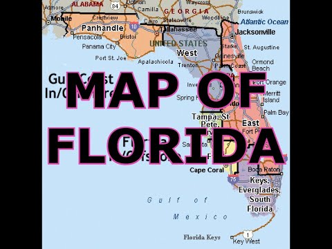
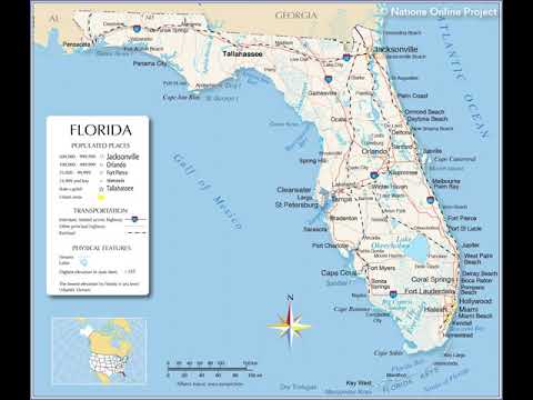
map of Panama City Florida

Показать описание
Panama City is a city in and the county seat of Bay County, Florida, United States. Located along U.S. Route 98, it is the largest city between Tallahassee and Pensacola. It is the more populated of two principal cities of the Panama City–Lynn Haven, Florida Metropolitan Statistical Area. Panama City was catastrophically damaged when Hurricane Michael made landfall as a Category 5 hurricane on October 10, 2018. As of the 2020 census, the population was 32,939, down from the figure of 36,484 at the 2010 census.
When Panama City was incorporated in 1909, its original city limits were 15th Street (Hwy 98) on the north, Balboa Avenue on the west and Bay Avenue on the east. Two military bases make the federal government the largest employer. Other major industrial employers in the Bay County area include Eastern Shipbuilding Group, Gulf Power, WestRock, Trane, L-3 Communications, ARINC, and JENSEN-GROUP
Real estate
In 2006, Panama City was named the best place to invest in real estate in the US
Military
Tyndall Air Force Base is east of the city. The HHT 1-153 CAV is stationed there. It is part of Florida Army National Guard's 53rd Infantry Brigade. The city is also home to the U.S. Navy's Naval Support Activity Panama City which is home to various research and training projects. The city is also approximately 100 miles south of Fort Rucker, Alabama, home to the US Army's Aviation Center of Excellence.
Retail
The city's main retail center was the Panama City Mall until it was permanently closed after Hurricane Michael. In August 2020, Panama City Mall released the plans to the mall. The plans for the mall includes a hotel, shops, and restaurants. Another local retail center is the Bay City Pointe, on FL 368 (locally known as 23rd St.). Pier Park, on the beach across the Hathaway Bridge spanning St. Andrews Bay, is a third local retail center. Others retail areas in the Panama City Metro are the 15th Street Shopping Strip (A area between Harrison Ave/US Highway 231 and Beck Ave/US Bus 98/State Road 390), 23rd Street Shopping Strip, Downtown Panama City, Historic St. Andrews, and Millville Historic District.
Hospitals
The city has two hospitals, Ascension Sacred Heart Bay (known as Bay Medical Sacred Heart until Hurricane Michael destroyed a large portion of it) and Gulf Coast Medical Center.
Transportation
Major Highways
US 98 (15th/ 18th St.)
US 231
SR 77 (Martin Luther King Jr. Blvd.)
SR 390 (St. Andrews Blvd.)
SR 368 (23rd St)
Roads
The two main east-to-west thoroughfares in Panama City proper are 23rd Street and U.S. Highway 98. FL-368 runs east–west across the northern part of the city as a bypass. U.S. Highway 98 runs east–west through the city itself, leading southeast 24 mi (39 km) to Mexico Beach and west 10 mi (16 km) to Panama City Beach.
The two main north-to-south thoroughfares in the city are Martin Luther King Boulevard, otherwise known as FL-77 and U.S. Highway 231. FL-77 leads north 6 mi (10 km) to the Panama City suburb of Lynn Haven. U.S. Highway 231 begins its national journey northward in the city, leading northeast 83 mi (134 km) to Dothan, Alabama.
Other more local highways run through the city, including many Bay County roads.
Bridges
Because of the city's position on St. Andrews Bay, bridges are very important to the area, and most directions into or out of the city require the use of one of three large bridges to cross parts of the bay. These are the Bailey Bridge to the north on Hwy 77, the Dupont Bridge to the south on Hwy 98 and the Hathaway Bridge to the west on Hwy 98. The largest of these is the Hathaway Bridge, which is the only direct connection between Panama City and Panama City Beach.
Rail
The Bay Line Railroad has an 82-mile (132 km) rail line running north to Dothan, Alabama, to a connection with CSX Transportation and Norfolk Southern.
Bus transportation
Local transit is handled by the Baytown Trolley services. Service generally runs Monday–Saturday from 6 AM to 7 PM.
Air transportation
The city was served by the Panama City-Bay County International Airport (PFN) until May 22, 2010. It was replaced by the Northwest Florida Beaches International Airport (ECP) with Southwest Airlines, Delta Air Lines, and United Airlines. In June 2018, ECP also added American Airlines.
Port
The Port of Panama City is on St. Andrews Bay. Panama City is located at 30°10′28″N 85°39′52″W (30.174451, –85.664480) within the Florida Panhandle and along the Emerald Coast. According to the United States Census Bureau, the city limits encompass an area of 35.4 square miles (91.8 km2), of which 29.3 square miles (75.8 km2) is land and 6.2 square miles (16.0 km2), or 17.39%, is water.
Climate
Panama City has a humid subtropical climate, with short, mild winters and long, hot and humid summers. In January, the average low is 42.6 °F (5.9 °C), and in July the average high is 91.1 °F (32.8 °C). mapa de Ciudad de Panama Florida mapa de Ciudad de Panama florida
 0:11:05
 0:11:05
 0:01:50
 0:05:47
 0:18:41
 0:01:23
 0:00:06
 0:12:44
 0:10:20
 0:19:15
 0:08:02
 0:06:07
 0:17:08
 0:15:02
 0:11:05
 0:09:30
 0:02:10
 0:15:32
 0:01:07
 0:01:56
 0:05:08
 0:03:34
 0:21:25
 0:04:05