filmov
tv
Combining Total Station, GPS & Levelling Survey Data

Показать описание
In today's video we'll look at a few different methods to combine different land surveying data types, both in the field and in the office.
00:00 - Introduction
00:29 - Why combine data?
01:40 - In the field
02:26 - SIDE NOTE
03:38 - Back to it
06:37 - In the office
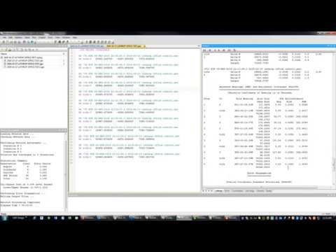
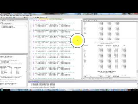
10:05 - Least Squares
12:38 - STAR*NET
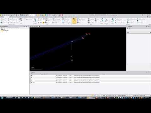
14:23 - Using Real Data
15:27 - Static Data
19:29 - RTK data
21:54 - Total Station Data
23:42 - Levelling Data
26:30 - Final Thoughts
00:00 - Introduction
00:29 - Why combine data?
01:40 - In the field
02:26 - SIDE NOTE
03:38 - Back to it
06:37 - In the office
10:05 - Least Squares
12:38 - STAR*NET
14:23 - Using Real Data
15:27 - Static Data
19:29 - RTK data
21:54 - Total Station Data
23:42 - Levelling Data
26:30 - Final Thoughts
 0:04:18
Combining Total Station and GPS Data from different manufacturers
 0:28:20
Combining Total Station, GPS & Levelling Survey Data
 0:17:10
Total Station vs. GNSS Receiver: Which is the Better Surveying Tool?
 0:10:31
SurvCE Mixing Total Station and GPS Observations at Grid
 0:52:21
Integrating Total Station, GNSS and Level Data Workflow (October 2015 TBC Power Hour)
 0:04:09
StarNet Network Adjustment With RTN GPS and Total Station Vectors - Part 5
 0:12:44
StarNet Network Adjustment With RTN GPS and Total Station Vectors - Part 4
 0:53:41
Mixed Surveying GNSS and Total Station
 0:06:10
StarNet Network Adjustment Of RTN GPS and Total Station Vectors - Part 1
 0:21:08
Star*Net Adjustment Of Static GPS Vectors and Total Station Data
 0:20:31
Integrated Surveying with Trimble Access
 0:06:28
Siteworks Setting GPS Control points for SPS930 setup
 0:01:49
GNSS Receiver vs. Total Station | How To Get Higher Efficiency?
 0:05:55
Precision GPS: Grid vs. Ground
 0:02:38
Carlson Hybrid+ | Survey with GNSS and a Robotic Total Station AT THE SAME TIME
 0:03:43
How To Setup Secondary Control Points With Your Robotic Total Station Leica iCON iCR70
 0:04:07
TOTAL STATION || GPS || SURVEYING
 0:05:45
ESRI UC - Concept Total Station on a GPS pole
 0:05:49
How to calculate scale factor of gps bench mark points
 0:09:03
Surveying: Quick Total Station Setup
 0:08:56
GPS vs Total Station Survey _ Lecture _ 5 _ 3
 0:12:42
Grid vs. Ground Coordinates Discussion
 0:53:49
Working with Total Station Data
 0:00:14
Use Mountlaser Bipods and GPS Poles for Precision Measurement #laserdistancemeter#surveying
Комментарии