filmov
tv
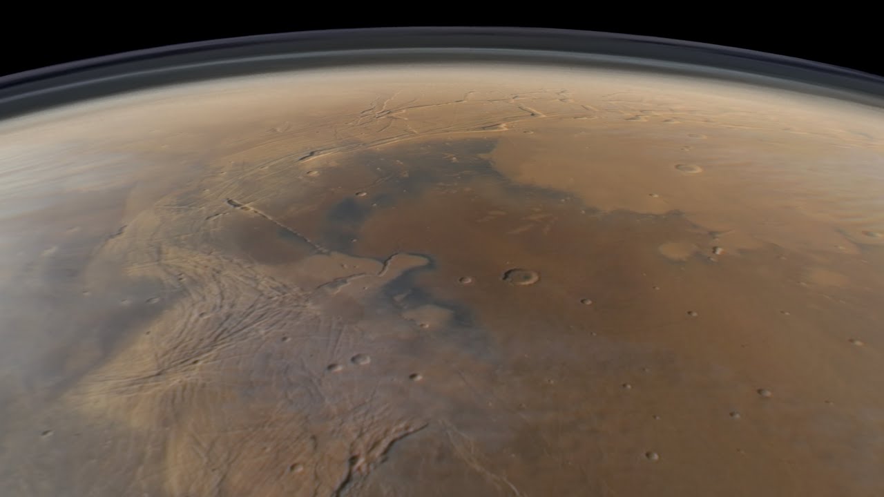
Mars Reconnaissance Orbiter - August 1, 2012 - Claritas Fossae / Noctis Labyrinthus / Tharsis Montes
Показать описание
This video is a simulated view of the Martian surface from NASA's Mars Reconnaissance Orbiter (MRO) mission, rendered in Blender from data taken the spacecraft's MARCI (Mars Color Imager) camera during one orbit on August 1, 2012. This orbit occurred during the Mars' northern midsummer, with most of the Martian Boreal Circle experiencing the midnight Sun. This also coincides with the waning Aphelion Cloud Belt, where thick water ice clouds form over Mars' equatorial region in the mid-afternoon. When this orbit occurred, water ice clouds were mostly limited to the summit regions of the Tharsis volcanoes. The southern seasonal frost cap was also near its maximum annual extent at this time.
This flyover is rendered in Blender at approximately true orbital speed, using a 35 mm camera to approximate a human's view out of a spacecraft window at MRO's ~250 km orbital altitude.
Regions and Landmarks:
00:00 - Aonia Terra
04:00 - Icaria Planum
07:00 - Thaumasia Rise
8:30 - Claritas Rupes
14:00 - Syria Planum
16:00 - Western Noctis Labyrinthus
18:00 - Pavonis Mons
20:00 - Poynting Crater
21:00 - Ascraeus Mons
25:00 - Ceraunius Fossae
30:00 - Alba Mons
35:00 - Vastitas Borealis
38:00 - Scandia Colles
40:45 - Scandia Cavi
42:00 - Olympia Planum
43:30 Boreum Planum
 0:00:45
OTD in Space – August 12: Mars Reconnaissance Orbiter Launched
 0:45:01
Mars Reconnaissance Orbiter - August 1, 2012 - Claritas Fossae / Noctis Labyrinthus / Tharsis Montes
 0:00:59
NASA’s Mars Reconnaissance Orbiter Finds Meteorite Crater | Spacing Out
 0:05:48
Video file: NASA's Mars Reconnaissance Orbiter Still Going Strong a Deacde After Launch
 0:00:10
Mars Reconnaissance Orbiter (MRO) orbiting Mars
 0:11:49
What Did the Mars Reconnaissance Orbiter Discover on Mars?
 0:00:34
Mars Reconnaissance Orbiter (MRO)
 0:02:21
NASA Video: Magnificent Mars 10 Years of Mars Reconnaissance Orbiter
 0:09:49
Watch video full HD Mars Reconnaissance Orbiter
 0:11:09
LINDAS IMAGENS DE MARTE TIRADA PELA SONDA DA NASA 'MARS RECONNAISSANCE ORBITER (MRO)
 0:00:35
Space Exploration - What is the Mars Reconnaissance Orbiter
 0:07:57
Mars - ARES Part 06 - Mars Reconnaissance Orbiter (MRO)
 0:00:49
Mars Reconnaissance Orbiter Flying Over Mars
 0:05:25
Mars in 4K | MARS Reconnaissance Orbiter HiRISE Photo stream
 3:02:39
High Resolution Images from Mars Reconnaissance Orbiter HiRISE!
 0:01:01
Mars Reconnaissance Orbiter #shorts
 0:02:02
Mars Reconnaissance Orbiter launch
 0:00:34
Exploring the Dynamic Mars: Unveiling the Planet's Ever Changing Patterns
 0:00:30
#mars reconnaissance orbiter spacecraft #zooming #shortsyoutube #viralshort #like #solarsystem
 0:00:09
Who build the Mars Reconnaissance Orbiter for NASA?
 0:00:42
The Mars Reconnaissance Orbiter......#shorts
 0:00:21
Nasa Mars reconnaissance orbiter #antrikshgyaan #nasa
 0:00:55
Enhanced Footage From The Mars Reconnaissance Orbiter's HiRISE Camera Shows The Impact Crater A...
 0:06:45
Best of NASA's Mars Reconnaissance Orbiter with Henry Purcell | Dido's lament: Solar Sound...
Комментарии