filmov
tv
Importance of Corridors and How GIS Technology Helps Safeguard Them

Показать описание
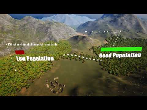
How important is habitat connectivity for wide-ranging species like the tiger? How can #geospatial #technology help assess habitat connectivity? What are the tools used to collect, process and present spatial data, so that it guides policy? Girish Punjabi, Conservation Biologist with WCT, answers these questions in this Instagram Live session held on the occasion of International Tiger Day. Our other speaker, Spatial Ecologist and Analyst Sheetal Kolhe could not join this session due to technical difficulties. Both the speakers will be Live on our social media platforms in the coming days. Please follow us to get updates.
If you have any further questions, you can directly contact our expert via email.
Girish Punjabi
As part of the #TalkingConservation series, we will conduct many more Live sessions on our social media channels in the coming days and months. Please follow us to get updates.
If you have any further questions, you can directly contact our expert via email.
Girish Punjabi
As part of the #TalkingConservation series, we will conduct many more Live sessions on our social media channels in the coming days and months. Please follow us to get updates.
 0:13:18
 0:04:14
 0:04:11
 0:18:14
 0:02:16
 0:02:28
 0:00:28
 0:02:35
 0:01:00
 0:02:53
 0:02:38
 0:02:00
 0:04:02
 0:00:46
 0:10:22
 0:03:26
 0:01:37
 0:01:55
 0:03:53
 0:00:40
 0:01:23
 0:05:03
 0:01:20
 0:02:06