filmov
tv
GIS Raster Processing (theory)

Показать описание
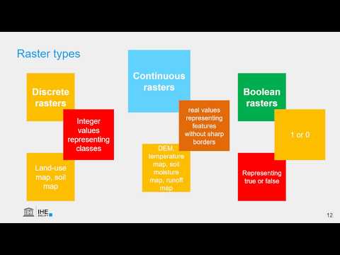
This video shows how to use map algebra for raster processing and analysis in geographic information systems (GIS). You will learn about raster calculation, map algebra syntax, local, focal, zonal and global operations. The video also explains boolean operators.
Subscribe to the YouTube Channel for updates!
Subscribe to the YouTube Channel for updates!
 0:13:58
GIS Raster Processing (theory)
 0:15:38
Raster data model in GIS (theory)
 0:16:45
Raster Data Theory (2/6): Raster Fundamentals
 0:03:47
A brief introduction to GIS Data: raster and vector
 0:35:36
GIS ~ Raster data model ~ processing
 0:10:11
Understanding Vector vs Raster data for GIS
 0:10:58
Raster Data Theory (4/6): Raster Processing 1
 0:05:57
Raster Data Theory (6/6): Raster Processing 3
 0:11:29
Raster Data Theory (5/6): Raster Processing 2
 0:07:07
Tutorial #2 of 3 - Understanding Flow Accumulation in GIS from raster Data of elevation ?
 0:02:39
GIS: Data Type and Data Structure: Spatial, Non Spatial, Raster and Vector
 0:24:55
GIS Module 02: The Raster Data Model
 0:27:30
Introduction to GIS - Raster and Vector Data Model Comparison
 0:31:57
Introduction to Spatial Analysis
 0:15:03
Raster Analysis
 0:04:28
Working with raster data
 0:42:25
Raster data models and comparisons with vector
 0:31:39
Data Structure in GIS – Raster and Vector Data
 0:12:51
Local operations in Raster data Analysis
 0:01:33
What is Digital Elevation Model or DEM?
 1:48:28
Raster Application and Analysis
 0:55:07
Raster Analysis and Image Processing in ArcGIS Enterprise
 0:22:07
Representation - Raster data
 0:09:18
Raster Data Theory (1/6): Introduction to Rasters and Weather Maps
Комментарии